
Make a donation
Pahalgam topographic map
Click on the map to display elevation.
Make a donation
Pahalgam
Pahalgam (Hindustani pronunciation: [pɛhɛlɡaːm]), known as Pahalgom (Kashmiri pronunciation: [pəhəlʲɡoːm]; lit. 'village of shepherds' in Kashmiri) is a town and a notified area committee, near Anantnag city in the Anantnag district of the Indian-administered union territory of Jammu and Kashmir. It is a popular tourist destination and hill station. Its lush green meadows and pristine waters attract thousands of tourists from all over the world each year. It is located 45 kilometres (28 mi) from Anantnag on the banks of Lidder River at an altitude of 7,200 feet (2,200 m). Pahalgam is the headquarters of one of the eleven tehsils of Anantnag district.
Make a donation
About this map
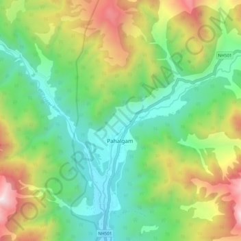
Name: Pahalgam topographic map, elevation, terrain.
Location: Pahalgam, Anantnag district, Jammu and Kashmir, 192126, India (33.99220 75.28265 34.07220 75.36265)
Average elevation: 2,700 m
Minimum elevation: 2,082 m
Maximum elevation: 3,909 m
Make a donation
Other topographic maps
Click on a map to view its topography, its elevation and its terrain.