
Stroud topographic map
Interactive map
Click on the map to display elevation.
About this map
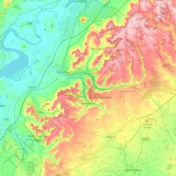
Name: Stroud topographic map, elevation, terrain.
Location: Stroud, Gloucestershire, England, United Kingdom (51.58984 -2.54081 51.85046 -2.06871)
Average elevation: 113 m
Minimum elevation: 0 m
Maximum elevation: 302 m
Other topographic maps
Click on a map to view its topography, its elevation and its terrain.
Bagpath
United Kingdom > England > Gloucestershire > Cotswold District
Bagpath, Kingscote, Cotswold District, Gloucestershire, England, GL8 8YG, United Kingdom
Average elevation: 198 m
Didmarton
United Kingdom > England > Gloucestershire > Cotswold District
Didmarton, Cotswold District, Gloucestershire, England, GL9 1DR, United Kingdom
Average elevation: 141 m
Joys Green
United Kingdom > England > Gloucestershire > Forest of Dean > Upper Lydbrook
Joys Green, Lydbrook, Upper Lydbrook, Forest of Dean, Gloucestershire, England, GL17 9QU, United Kingdom
Average elevation: 142 m
Sharpness
United Kingdom > England > Gloucestershire > Stroud
Sharpness, Stroud, Gloucestershire, England, GL13 9PE, United Kingdom
Average elevation: 17 m
Gloucester
United Kingdom > England > Gloucestershire > Gloucester
Gloucester, Gloucestershire, South West England, England, GL1 2AP, United Kingdom
Average elevation: 83 m