
Make a donation
Jägersburg topographic map
Click on the map to display elevation.
Make a donation
Jägersburg
Jägersburg liegt ca. 5 km nordwestlich von Homburg auf einer Höhe von 270 m ü. NHN.
Make a donation
About this map
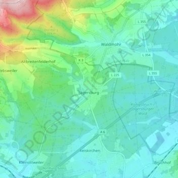
Name: Jägersburg topographic map, elevation, terrain.
Location: Jägersburg, Homburg, Saarpfalz-Kreis, Saarland, Deutschland (49.35762 7.27372 49.38637 7.36934)
Average elevation: 284 m
Minimum elevation: 233 m
Maximum elevation: 477 m
Make a donation
Other topographic maps
Click on a map to view its topography, its elevation and its terrain.
Königsbruch / Jägersburger Wald
Deutschland > Saarland > Saarpfalz-Kreis > Homburg
Average elevation: 257 m
Schwarzenbach
Deutschland > Saarland > Saarpfalz-Kreis > Homburg
Das im Osten des Saarlandes gelegene Homburg grenzt an die Ausläufer des Pfälzerwaldes. Die westlichen Stadtteile Beeden, Schwarzenbach, Wörschweiler, Schwarzenacker, Einöd und Ingweiler liegen im bzw. am Tal der Blies. Der teilweise verwendete Namenszusatz „(Saar)“ (auch „/Saar“) ist ein Relikt…
Average elevation: 268 m
Make a donation
Kirrberg
Deutschland > Saarland > Saarpfalz-Kreis > Homburg
Das im Osten des Saarlandes gelegene Homburg grenzt an die Ausläufer des Pfälzerwaldes. Die westlichen Stadtteile Beeden, Schwarzenbach, Wörschweiler, Schwarzenacker, Einöd und Ingweiler liegen im bzw. am Tal der Blies. Der teilweise verwendete Namenszusatz „(Saar)“ (auch „/Saar“) ist ein Relikt…
Average elevation: 305 m
Schwarzenbach
Deutschland > Saarland > Saarpfalz-Kreis > Homburg
Das im Osten des Saarlandes gelegene Homburg grenzt an die Ausläufer des Pfälzerwaldes. Die westlichen Stadtteile Beeden, Schwarzenbach, Wörschweiler, Schwarzenacker, Einöd und Ingweiler liegen im bzw. am Tal der Blies. Der teilweise verwendete Namenszusatz „(Saar)“ (auch „/Saar“) ist ein Relikt…
Average elevation: 268 m