
Piekberg topographic map
Interactive map
Click on the map to display elevation.
About this map
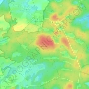
Name: Piekberg topographic map, elevation, terrain.
Average elevation: 136 m
Minimum elevation: 111 m
Maximum elevation: 164 m
Other topographic maps
Click on a map to view its topography, its elevation and its terrain.
Nationalpark Jasmund
Deutschland > Mecklenburg-Vorpommern > Sassnitz
Nationalpark Jasmund, Hochuferweg Sassnitz–Königstuhl, Forsthaus Werder, Sassnitz, Vorpommern-Rügen, Mecklenburg-Vorpommern, 18546, Deutschland
Average elevation: 67 m
UNESCO-Weltnaturerbe „Alte Buchenwälder Deutschlands“ – Teilgebiet Jasmund
Deutschland > Mecklenburg-Vorpommern > Sassnitz > Werder
UNESCO-Weltnaturerbe „Alte Buchenwälder Deutschlands“ – Teilgebiet Jasmund, Waldhalle, Wedding, Werder, Sassnitz, Vorpommern-Rügen, Mecklenburg-Vorpommern, 18546, Deutschland
Average elevation: 62 m