
Graça topographic map
Interactive map
Click on the map to display elevation.
About this map
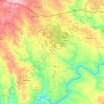
Name: Graça topographic map, elevation, terrain.
Location: Graça, Pedrógão Grande, Leiria, Portugal (39.85026 -8.26140 39.93603 -8.18511)
Average elevation: 334 m
Minimum elevation: 118 m
Maximum elevation: 563 m
Other topographic maps
Click on a map to view its topography, its elevation and its terrain.
Romão
Portugal > Leiria > Pedrógão Grande
Romão, Pedrógão Grande, Leiria, 3270-099, Portugal
Average elevation: 310 m
Troviscais Fundeiros
Portugal > Leiria > Pedrógão Grande
Troviscais Fundeiros, Pedrógão Grande, Leiria, 3270-066, Portugal
Average elevation: 366 m
Pesos Cimeiros
Portugal > Leiria > Pedrógão Grande
Pesos Cimeiros, Pedrógão Grande, Leiria, 3270-066, Portugal
Average elevation: 386 m
Ramalho
Portugal > Leiria > Pedrógão Grande
Ramalho, Vila Facaia, Pedrógão Grande, Leiria, 3270-225, Portugal
Average elevation: 368 m
Atalaia Fundeira
Portugal > Leiria > Pedrógão Grande > Atalaia Fundeira
Atalaia Fundeira, Graça, Pedrógão Grande, Leiria, 6100-290, Portugal
Average elevation: 278 m
Vila Facaia
Portugal > Leiria > Pedrógão Grande
Vila Facaia, Pedrógão Grande, Leiria, 3270-225, Portugal
Average elevation: 430 m