
Make a donation
Batna topographic map
Click on the map to display elevation.
Make a donation
Batna
The origins of the name of the city and province of Batna are not clear, but most historians agree that it is of Arabic origin: m'batna, meaning: "Where we sleep this night". Capital of the highlands situated between the Tell Atlas in the north and the Saharan Atlas in the south, with the Chott el Hodna in the middle, it constitutes a naturally protected passage between south and north. Its climate is moderate, hot and dry during summer time, due to its altitude (it being 800 metres above sea level) the winter is tough, snowy and at times cold (with temperatures of -15 °C recorded on some cold winter nights). This geo-political position is the origin of the last economy merging city due to a high commercial exchange rate between the north's seaward opening, and the south's source of all the wealth of the country (including reserves of oil, natural gas, iron and many minerals).
Make a donation
About this map
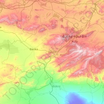
Name: Batna topographic map, elevation, terrain.
Location: Batna, Algeria (34.75362 4.74066 35.92275 6.79281)
Average elevation: 720 m
Minimum elevation: -25 m
Maximum elevation: 2,259 m
Make a donation
Other topographic maps
Click on a map to view its topography, its elevation and its terrain.
Algiers
Algeria > Algiers > Sidi M'Hamed District > Alger-Centre
Algiers was a walled city from the time of the deys until the close of the 19th century. The French, after their occupation of the city (1830), built a rampart, parapet and ditch, with two terminal forts, Bab Azoun باب عزون to the south and Bab-el-Oued اد to the north. The forts and part of the…
Average elevation: 45 m
Beni Brahim
Algeria > Setif > Beni Ouartilane District > Ain Lagradj > Beni Brahim
Average elevation: 1,020 m