
Thank you for supporting this site ❤️
Make a donation
Make a donation
Kathgodam topographic map
Click on the map to display elevation.
Thank you for supporting this site ❤️
Make a donation
Make a donation
Kathgodam
Kathgodam is located at 29°16′N 79°32′E / 29.27°N 79.53°E / 29.27; 79.53. It has an average elevation of 554 metres (1,483 feet). It is situated on the banks of the Gaula river.
Thank you for supporting this site ❤️
Make a donation
Make a donation
About this map
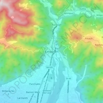
Name: Kathgodam topographic map, elevation, terrain.
Average elevation: 760 m
Minimum elevation: 431 m
Maximum elevation: 1,617 m
Thank you for supporting this site ❤️
Make a donation
Make a donation