
Murtal topographic map
Interactive map
Click on the map to display elevation.
About this map
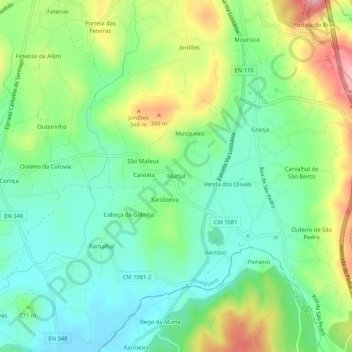
Name: Murtal topographic map, elevation, terrain.
Average elevation: 268 m
Minimum elevation: 206 m
Maximum elevation: 387 m
Other topographic maps
Click on a map to view its topography, its elevation and its terrain.
Sandoeira
Portugal > Leiria > Pussos São Pedro > Sandoeira
Sandoeira, Pussos São Pedro, Alvaiázere, Leiria, 3250-350, Portugal
Average elevation: 264 m