
Make a donation
Marsabit County topographic map
Click on the map to display elevation.
Make a donation
Marsabit County
The county is located in central north Kenya. It borders the eastern shore of Lake Turkana. Important topographical features are: Ol Donyo Ranges 2,066 m [6,778 ft] in the southwest, Mount Marsabit 1,865 m [6,119 ft] in the central part of the county, Hurri Hills 1,685 m [5,528 ft] in the northeastern part of the county, Mount Kulal 2,235 m [7,333 ft] in the northwest and the mountains around Sololo-Moyale escarpment up to 1,400 m [4,600 ft] in the northeast. The Chalbi Desert makes up much of the center region of the county.
Make a donation
About this map
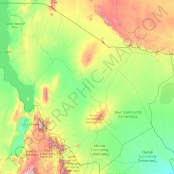
Name: Marsabit County topographic map, elevation, terrain.
Location: Marsabit County, Eastern, Kenya (1.26103 36.04932 4.45507 39.34650)
Average elevation: 699 m
Minimum elevation: 218 m
Maximum elevation: 2,806 m
Make a donation
Other topographic maps
Click on a map to view its topography, its elevation and its terrain.