Suhaj topographic map
Interactive map
Click on the map to display elevation.
About this map
![Suhaj topographic map, elevation, terrain](/pub/maps/relation/vptj/kxpvkl/thumbnail.jpg)
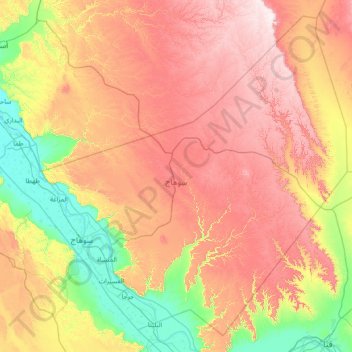
Name: Suhaj topographic map, elevation, terrain.
Location: Suhaj, Egypt (26.19181 31.34269 27.37428 32.79869)
Average elevation: 349 m
Minimum elevation: 51 m
Maximum elevation: 745 m
Other topographic maps
Click on a map to view its topography, its elevation and its terrain.
![Mudiriyat al Gharbiyah topographic map, elevation, terrain](/pub/maps/node/d8kl/4dxpn51h/icon.jpg)
Mudiriyat al Gharbiyah
Mudiriyat al Gharbiyah, Seberbay, مديرية الغربية, Western, 31733, Egypt
Average elevation: 46 m
![Tizmant East Village topographic map, elevation, terrain](/pub/maps/way/h5tp/qzts99tj/icon.jpg)
Tizmant East Village
Tizmant East Village, Bani Sweif, 62725, Egypt
Average elevation: 30 m
![Marsa Matruh topographic map, elevation, terrain](/pub/maps/node/h6rr/qrzstzs/icon.jpg)
Marsa Matruh
Egypt > Matrouh Governorate > Marsa Matruh
Marsa Matruh, Matrouh Governorate, Egypt
Average elevation: 37 m
![Al Shaykh Fadl topographic map, elevation, terrain](/pub/maps/node/64f3/3kbrzl18/icon.jpg)
Al Shaykh Fadl
Egypt > Minya Governate > Al Shaykh Fadl
Al Shaykh Fadl, Markaz Samalut, Minya Governate, Egypt
Average elevation: 35 m
![Lake Nasser topographic map, elevation, terrain](/pub/maps/relation/918/kwfnh/icon.jpg)
Lake Nasser
Egypt > Aswan Governorate > Al Madiq
Lake Nasser, Al Madiq, Aswan Governorate, Egypt
Average elevation: 298 m