
Thank you for supporting this site ❤️
Make a donation
Make a donation
Poupehan topographic map
Click on the map to display elevation.
Thank you for supporting this site ❤️
Make a donation
Make a donation
About this map
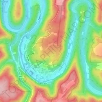
Name: Poupehan topographic map, elevation, terrain.
Location: Poupehan, Bouillon, Neufchâteau, Luxembourg, Wallonia, Belgium (49.80175 4.99170 49.83480 5.02742)
Average elevation: 273 m
Minimum elevation: 187 m
Maximum elevation: 383 m
Thank you for supporting this site ❤️
Make a donation
Make a donation
Other topographic maps
Click on a map to view its topography, its elevation and its terrain.