
Thank you for supporting this site ❤️
Make a donation
Make a donation
Stockem topographic map
Click on the map to display elevation.
Thank you for supporting this site ❤️
Make a donation
Make a donation
About this map
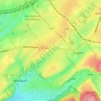
Name: Stockem topographic map, elevation, terrain.
Location: Stockem, Eupen, Verviers, Liège, Wallonie, 4700, Belgique (50.61141 5.99410 50.65141 6.03410)
Average elevation: 278 m
Minimum elevation: 230 m
Maximum elevation: 337 m
Thank you for supporting this site ❤️
Make a donation
Make a donation
Other topographic maps
Click on a map to view its topography, its elevation and its terrain.