
Thank you for supporting this site ❤️
Make a donation
Make a donation
Picote topographic map
Click on the map to display elevation.
Thank you for supporting this site ❤️
Make a donation
Make a donation
About this map
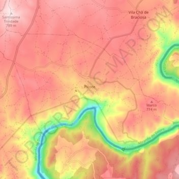
Name: Picote topographic map, elevation, terrain.
Average elevation: 651 m
Minimum elevation: 388 m
Maximum elevation: 791 m
Thank you for supporting this site ❤️
Make a donation
Make a donation
Other topographic maps
Click on a map to view its topography, its elevation and its terrain.
Fonte de Aldeia
Portugal > Distrito de Bragança > Miranda do Douro > Vila Chã de Braciosa
Average elevation: 734 m
Thank you for supporting this site ❤️
Make a donation
Make a donation