
Thank you for supporting this site ❤️
Make a donation
Make a donation
Kalruhi topographic map
Click on the map to display elevation.
Thank you for supporting this site ❤️
Make a donation
Make a donation
About this map
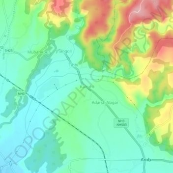
Name: Kalruhi topographic map, elevation, terrain.
Location: Kalruhi, Amb, Una, Himachal Pradesh, 177203, India (31.68208 76.08150 31.72208 76.12150)
Average elevation: 510 m
Minimum elevation: 452 m
Maximum elevation: 632 m
Thank you for supporting this site ❤️
Make a donation
Make a donation