
Thank you for supporting this site ❤️
Make a donation
Make a donation
Langdon topographic map
Click on the map to display elevation.
Thank you for supporting this site ❤️
Make a donation
Make a donation
About this map
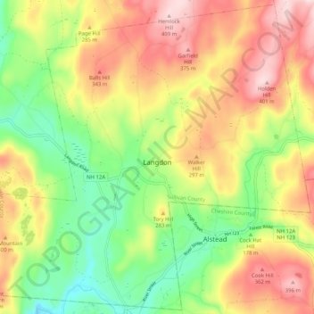
Name: Langdon topographic map, elevation, terrain.
Location: Langdon, Sullivan County, New Hampshire, United States (43.13212 -72.43209 43.20441 -72.33033)
Average elevation: 239 m
Minimum elevation: 82 m
Maximum elevation: 413 m
Thank you for supporting this site ❤️
Make a donation
Make a donation
Other topographic maps
Click on a map to view its topography, its elevation and its terrain.
Thank you for supporting this site ❤️
Make a donation
Make a donation
Mill Hollow
United States > New Hampshire > Sullivan County > Plainfield > Mill Hollow
Average elevation: 313 m