
Make a donation
Servance topographic map
Click on the map to display elevation.
Make a donation
Servance
Servance est traversée par la rivière Ognon, qui y présente une cascade, le Saut de l'Ognon ; la rivière prend sa source plus haut, dans la commune de Château - Lambert, à 904 mètres d'altitude.
Make a donation
About this map
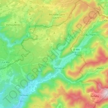
Name: Servance topographic map, elevation, terrain.
Average elevation: 596 m
Minimum elevation: 345 m
Maximum elevation: 1,050 m
Make a donation
Other topographic maps
Click on a map to view its topography, its elevation and its terrain.
Magny Maubert
France > Bourgogne-Franche-Comté > Haute-Saône > Servance-Miellin
Average elevation: 577 m
Les Breuchots
France > Bourgogne-Franche-Comté > Haute-Saône > Servance-Miellin
Average elevation: 564 m
Pré Boichey
France > Bourgogne-Franche-Comté > Haute-Saône > Servance-Miellin
Average elevation: 563 m
Make a donation
Le Voirmet
France > Bourgogne-Franche-Comté > Haute-Saône > Servance-Miellin > Miellin
Average elevation: 796 m
Le Grilloux
France > Bourgogne-Franche-Comté > Haute-Saône > Servance-Miellin > Le Grilloux
Average elevation: 587 m
Servance
France > Bourgogne-Franche-Comté > Haute-Saône > Servance-Miellin > Servance
Average elevation: 527 m
Les Évaudois
France > Bourgogne-Franche-Comté > Haute-Saône > Servance-Miellin > Les Évaudois
Average elevation: 549 m
Make a donation
L'Enclose du Monthury
France > Bourgogne-Franche-Comté > Haute-Saône > Servance-Miellin
Average elevation: 576 m