
Thank you for supporting this site ❤️
Make a donation
Make a donation
Kalispell topographic map
Click on the map to display elevation.
Thank you for supporting this site ❤️
Make a donation
Make a donation
Kalispell
Kalispell is located at 48°11′52″N 114°18′58″W / 48.19778°N 114.31611°W / 48.19778; -114.31611 (48.197801, −114.316068), at an elevation of 2,956 feet (901 m).
Thank you for supporting this site ❤️
Make a donation
Make a donation
About this map
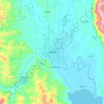
Name: Kalispell topographic map, elevation, terrain.
Average elevation: 1,055 m
Minimum elevation: 879 m
Maximum elevation: 2,248 m
Thank you for supporting this site ❤️
Make a donation
Make a donation