
Thank you for supporting this site ❤️
Make a donation
Make a donation
Sertã topographic map
Click on the map to display elevation.
Thank you for supporting this site ❤️
Make a donation
Make a donation
About this map
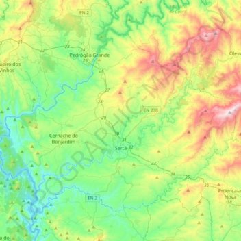
Name: Sertã topographic map, elevation, terrain.
Location: Sertã, Castelo Branco, Portugal (39.72698 -8.29312 39.94869 -7.91586)
Average elevation: 409 m
Minimum elevation: 104 m
Maximum elevation: 1,080 m
Thank you for supporting this site ❤️
Make a donation
Make a donation
Other topographic maps
Click on a map to view its topography, its elevation and its terrain.