
天门山 topographic map
Interactive map
Click on the map to display elevation.
About this map
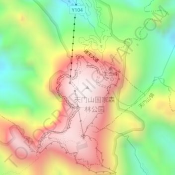
Name: 天门山 topographic map, elevation, terrain.
Location: 天门山, 永定区, 张家界市, 湖南省, 中国 (29.04983 110.47884 29.04993 110.47894)
Average elevation: 935 m
Minimum elevation: 441 m
Maximum elevation: 1,433 m
張家畀的主峰海拔为1518.6米,平均海拔在1400米之上。天门山国家森林公园面积达190多平方公里。天门山始于燕山构造期,后经过喜马拉雅山造山运动,以及千万年的风雨剥蚀,形成了喀斯特台型地貌。植被属于原始次生林。
Other topographic maps
Click on a map to view its topography, its elevation and its terrain.