
Make a donation
Atteln topographic map
Click on the map to display elevation.
Make a donation
About this map
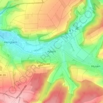
Name: Atteln topographic map, elevation, terrain.
Average elevation: 257 m
Minimum elevation: 176 m
Maximum elevation: 348 m
Make a donation
Other topographic maps
Click on a map to view its topography, its elevation and its terrain.
Bad Wünnenberg
Deutschland > Nordrhein-Westfalen > Kreis Paderborn
Die Stadt liegt im Süden des Kreises Paderborn und wird von den Städten Büren, Lichtenau, Salzkotten (alle im Kreis Paderborn) sowie Brilon und Marsberg (beide Hochsauerlandkreis) umschlossen. Landschaftlich gehört der größte Teil des Stadtgebietes zur Paderborner Hochfläche und damit zur Westfälischen…
Average elevation: 335 m
Delbrück
Deutschland > Nordrhein-Westfalen > Kreis Paderborn
Grundwasser kommt in den Lockergesteinen des Eiszeitalters im Delbrücker Höhenzug mäßig vor. Lediglich in den eiszeitlichen Lockergesteinen des Lippetals sind größere Grundwassermengen vorhanden, wobei diese durch eine geringdurchlässige Zwischenschicht zum Teil in zwei Stockwerke unterteilt sind.…
Average elevation: 94 m
Paderborn
Deutschland > Nordrhein-Westfalen > Kreis Paderborn > Paderborn
Die Kirchengründungen Bischof Meinwerks bildeten den Bestandteil eines geplanten Kirchenkreuzes aus vier Klöstern, von denen nur die beiden die Ost-West-Achse bildenden verwirklicht wurden. Für das von ihm gegründete Abdinghofkloster im Westen der Stadt berief er Mönche aus Cluny, und für die…
Average elevation: 155 m
Make a donation
Borchen
Deutschland > Nordrhein-Westfalen > Kreis Paderborn
Die als „große Landgemeinde“ klassifizierte Gemeinde liegt auf einer Höhe zwischen 125 m ü. NN (im Almetal) und 334 m ü. NN (östlich von Dörenhagen) und bedeckt eine Fläche von 77,13 km². Den größten Flächenanteil nehmen Wald- und Landwirtschaftsfläche mit zusammen ca. 87,2 % ein, Siedlungs-…
Average elevation: 198 m
Salzkotten
Deutschland > Nordrhein-Westfalen > Kreis Paderborn
Der niedrigste Punkt des Stadtgebietes mit 81 Meter befindet sich im Stadtteil Mantinghausen, der höchste mit 263 Meter im Stadtteil Niederntudorf, das Rathaus im Zentrum der Stadt befindet sich auf einer Höhe von 96 m ü. NN.
Average elevation: 140 m
Atteln
Deutschland > Nordrhein-Westfalen > Kreis Paderborn > Atteln
Atteln gehört wie Ostwestfalen-Lippe insgesamt zum ozeanischen Klimabereich Nordwestdeutschlands, dem es geringe Temperaturgegensätze und milde Winter verdankt. Allerdings sind schon kontinentale Einflüsse wirksam. So liegt die Temperatur im Sommer höher und die Nächte sind kühler als in größerer Nähe…
Average elevation: 279 m
Büren
Deutschland > Nordrhein-Westfalen > Kreis Paderborn > Büren
Büren liegt im äußersten Südwesten der Region Ostwestfalen-Lippe nördlich des Sauerlands, am Südwestrand der Paderborner Hochfläche und westlich des Sintfelds im Herzen des Bürener Landes. In der Stadt mündet die Afte in die Alme. Das Stadtgebiet umfasst Höhenlagen von 190 bis 360 Meter über Normalnull.
Average elevation: 286 m
Make a donation
Westenholz
Deutschland > Nordrhein-Westfalen > Kreis Paderborn > Delbrück > Westenholz
Average elevation: 82 m
Bad Lippspringe
Deutschland > Nordrhein-Westfalen > Kreis Paderborn
Die Stadt liegt auf Höhen zwischen 120 und 429 m ü. NN.
Average elevation: 192 m
Altenbeken
Deutschland > Nordrhein-Westfalen > Kreis Paderborn
Altenbeken liegt in Höhen von 200 bis 400 m am westlichen Fuße des Eggegebirges im Naturpark Teutoburger Wald / Eggegebirge. In östlicher Richtung erstreckt sich das Weserbergland. Wenige Kilometer südlich befindet sich das östliche Sauerland. 15 km südwestlich liegt die Kreisstadt Paderborn. Der Ort…
Average elevation: 295 m
Make a donation
Hövelhof
Deutschland > Nordrhein-Westfalen > Kreis Paderborn
Vorherrschendes Gewässer der Gemeinde ist die Ems, deren Quellen unmittelbar nördlich der Gemeindegrenze auf Stukenbrocker Gebiet liegen. Weitere Fließgewässer, welche auf dem Gemeindegebiet entspringen oder es durchqueren, sind der Haustenbach, der Knochenbach, der Krollbach, der Kastenbach, der…
Average elevation: 117 m
Lichtenau
Deutschland > Nordrhein-Westfalen > Kreis Paderborn > Lichtenau
Der tiefste Punkt des Stadtgebiets liegt mit etwa 172 m ü. NN bei Henglarn, der höchste ist der Schneefelder Berg mit 428 m ü. NN 1 km nordwestlich der Stadtwüstung Blankenrode. Die mittlere Höhe des gesamten Stadtgebiets beträgt etwa 205 m ü. NN.
Average elevation: 318 m
Salzkotten
Deutschland > Nordrhein-Westfalen > Kreis Paderborn > Salzkotten
Der niedrigste Punkt des Stadtgebietes mit 81 Meter befindet sich im Stadtteil Mantinghausen, der höchste mit 263 Meter im Stadtteil Niederntudorf, das Rathaus im Zentrum der Stadt befindet sich auf einer Höhe von 96 m ü. NN.
Average elevation: 131 m
Aabachtalsperre
Deutschland > Nordrhein-Westfalen > Kreis Paderborn > Bad Wünnenberg
Die Aabachtalsperre liegt im Kreis Paderborn am Rand der Briloner Höhen zwischen Bad Wünnenberg im Nordwesten und Marsberg im Südosten. Das 27,2 km² große Einzugsgebiet der Talsperre erstreckt sich im Wesentlichen nach Südosten durch das Sintfeld und wird flankiert durch den „Fürstenberger Wald“ im…
Average elevation: 381 m
Make a donation
Wünnenberg
Deutschland > Nordrhein-Westfalen > Kreis Paderborn > Bad Wünnenberg
Average elevation: 353 m
Paderborn
Deutschland > Nordrhein-Westfalen > Kreis Paderborn
Die Kirchengründungen Bischof Meinwerks bildeten den Bestandteil eines geplanten Kirchenkreuzes aus vier Klöstern, von denen nur die beiden die Ost-West-Achse bildenden verwirklicht wurden. Für das von ihm gegründete Abdinghofkloster im Westen der Stadt berief er Mönche aus Cluny, und für die…
Average elevation: 164 m
Bleiwäsche
Deutschland > Nordrhein-Westfalen > Kreis Paderborn > Bad Wünnenberg
Average elevation: 416 m
Make a donation
Elsen
Deutschland > Nordrhein-Westfalen > Kreis Paderborn > Paderborn
Die katholische Pfarrkirche St. Dionysius und St. Urban liegt auf einer kleinen Anhöhe und beherrscht das Elsener Ortsbild. Der massige, fünfgeschossige, romanische Turm aus dem 11./12. Jahrhundert überragt heute wie damals alle anderen Gebäude des Ortes. Die Kirche war lange Zeit auch Mutterkirche der…
Average elevation: 113 m
Make a donation
Benhausen
Deutschland > Nordrhein-Westfalen > Kreis Paderborn > Paderborn
Benhausen liegt nordöstlich der Kernstadt Paderborn bei 51° 45' Nord und 8° 49' Ost im Norden der Paderborner Hochfläche am Westrand des Eggegebirges auf einer Höhe von 193 m ü. NN. Südlich des Dorfes fließt die Gotte, deren Abfluss durch das Hochwasserrückhaltebecken Benhausen reguliert wird. Die…
Average elevation: 198 m
Niederntudorf
Deutschland > Nordrhein-Westfalen > Kreis Paderborn > Salzkotten
Niederntudorf gehört wie Ostwestfalen-Lippe insgesamt zum ozeanischen Klimabereich Nordwestdeutschlands, dem es geringe Temperaturgegensätze und milde Winter verdankt. Allerdings sind schon kontinentale Einflüsse wirksam. So liegt die Temperatur im Sommer höher und die Nächte sind kühler als in…
Average elevation: 201 m
Make a donation
Haaren
Deutschland > Nordrhein-Westfalen > Kreis Paderborn > Bad Wünnenberg
Der Ortsname besteht aus dem allgemein gehaltenen Bestimmungswort har, das bedeutet Höhe, dies ist auch vom Haarstrang bekannt und einem Grundwort wie Harn, Harun, Haran oder Haram. So wurden von den Franken Heimsiedlungen benannt. Haaren liegt auf einer markanten Stelle der Turonstufe über dem Sintfeld. Der…
Average elevation: 309 m
Schloß Neuhaus
Deutschland > Nordrhein-Westfalen > Kreis Paderborn > Paderborn > Sennelager
Average elevation: 114 m
Dahl
Deutschland > Nordrhein-Westfalen > Kreis Paderborn > Paderborn
Dahl liegt südöstlich der Kernstadt Paderborn auf der Paderborner Hochfläche am Westrand des Eggegebirges auf einer Höhe von 218 m ü. NN. Durch das Dorf fließt der Ellerbach.
Average elevation: 272 m
Make a donation
Upsprunge
Deutschland > Nordrhein-Westfalen > Kreis Paderborn > Salzkotten
Upsprunge gehört wie Ostwestfalen-Lippe insgesamt zum ozeanischen Klimabereich Nordwestdeutschlands, dem es geringe Temperaturgegensätze und milde Winter verdankt. Allerdings sind schon kontinentale Einflüsse wirksam. So liegt die Temperatur im Sommer höher und die Nächte sind kühler als in größerer…
Average elevation: 139 m
Helmern
Deutschland > Nordrhein-Westfalen > Kreis Paderborn > Bad Wünnenberg
Die Alte Linde ist der Wappenbaum des Orts und wird im Dorfwappen dargestellt. Sie steht südlich des Dorfkerns, an der Sintfeldhöhenstraße, vor einem Einzelgehöft. Vor dem Baum steht ein Bildstock mit einer Statue des Hl. Sturmius, der die Linde ihren Namen zu verdanken hat. Die als Naturdenkmal…
Average elevation: 334 m
Verne
Deutschland > Nordrhein-Westfalen > Kreis Paderborn > Salzkotten > Verne
Verne gehört wie Ostwestfalen-Lippe insgesamt zum ozeanischen Klimabereich Nordwestdeutschlands, dem es geringe Temperaturgegensätze und milde Winter verdankt. Allerdings sind schon kontinentale Einflüsse wirksam. So liegt die Temperatur im Sommer höher und die Nächte sind kühler als in größerer Nähe…
Average elevation: 99 m
Büren
Deutschland > Nordrhein-Westfalen > Kreis Paderborn
Büren liegt im äußersten Südwesten der Region Ostwestfalen-Lippe nördlich des Sauerlands, am Südwestrand der Paderborner Hochfläche und westlich des Sintfelds im Herzen des Bürener Landes. In der Stadt mündet die Afte in die Alme. Das Stadtgebiet umfasst Höhenlagen von 190 bis 360 Meter über Normalnull.
Average elevation: 284 m
Make a donation
Anreppen
Deutschland > Nordrhein-Westfalen > Kreis Paderborn > Delbrück
Anreppen liegt im südöstlichen Winkel der Westfälischen Bucht direkt nördlich der Lippe bei 51° 45′ n. Br., 8° 34′ ö. L. auf einer Höhe von 90 m ü. NN. Laut der heute meist benutzten Einteilung im Handbuch der naturräumlichen Gliederung Deutschlands liegt der Ort in der Untereinheit 540.20 Obere…
Average elevation: 92 m
Ebbinghausen
Deutschland > Nordrhein-Westfalen > Kreis Paderborn > Lichtenau
Ebbinghausen gehört wie Ostwestfalen-Lippe insgesamt zum ozeanischen Klimabereich Nordwestdeutschlands, dem es geringe Temperaturgegensätze und milde Winter verdankt. Allerdings sind schon kontinentale Einflüsse wirksam. So liegt die Temperatur im Sommer höher und die Nächte sind kühler als in größerer…
Average elevation: 288 m
Make a donation
Wewelsburg
Deutschland > Nordrhein-Westfalen > Kreis Paderborn > Büren > Wewelsburg
Die Wewelsburg ist ein burgähnliches Renaissanceschloss im Stadtteil Wewelsburg der Stadt Büren im Kreis Paderborn, Nordrhein-Westfalen. Die Höhenburg liegt über dem Tal der Alme und ist eine der wenigen Burgen mit dreieckigem Grundriss in Deutschland. 1123 errichtete Graf Friedrich von Arnsberg an diesem…
Average elevation: 216 m
Herbram
Deutschland > Nordrhein-Westfalen > Kreis Paderborn > Lichtenau
Herbram gehört wie Ostwestfalen-Lippe insgesamt zum ozeanischen Klimabereich Nordwestdeutschlands, dem es geringe Temperaturgegensätze und milde Winter verdankt. Allerdings sind schon kontinentale Einflüsse wirksam. So liegt die Temperatur im Sommer höher und die Nächte sind kühler als in größerer…
Average elevation: 317 m
Schwaney
Deutschland > Nordrhein-Westfalen > Kreis Paderborn > Schwaney
Durch den Höhenunterschied zum Umland ist das Klima spürbar rauer. Bedingt durch die Hanglage an der Egge, kommt es in Schwaney häufig zu ergiebigem Steigungsregen.
Average elevation: 330 m
Make a donation
Tallesee Mittelsee
Deutschland > Nordrhein-Westfalen > Kreis Paderborn > Paderborn
Average elevation: 118 m
Sande
Deutschland > Nordrhein-Westfalen > Kreis Paderborn > Paderborn
Sande liegt landschaftlich im Südosten der Westfälischen Bucht an der Lippe, am Heddinghauser See und am Lippesee auf einer Höhe von 97 m ü. NN. Der niedrigste Punkt der Stadt Paderborn liegt in Sande auf einer Höhe von 94 m ü. NN. Der Ort gehört zum Stadtbezirk Schloß Neuhaus/Sande.
Average elevation: 103 m
Blankenrode
Deutschland > Nordrhein-Westfalen > Kreis Paderborn > Blankenrode
Blankenrode gehört wie Ostwestfalen-Lippe insgesamt zum ozeanischen Klimabereich Nordwestdeutschlands, dem es geringe Temperaturgegensätze und milde Winter verdankt. Allerdings sind schon kontinentale Einflüsse wirksam. So liegt die Temperatur im Sommer höher und die Nächte sind kühler als in größerer…
Average elevation: 367 m
Ostenland
Deutschland > Nordrhein-Westfalen > Kreis Paderborn > Delbrück > Wittendorf
Average elevation: 101 m
Make a donation
Grundsteinheim
Deutschland > Nordrhein-Westfalen > Kreis Paderborn > Lichtenau
Grundsteinheim gehört wie Ostwestfalen-Lippe insgesamt zum ozeanischen Klimabereich Nordwestdeutschlands, dem es geringe Temperaturgegensätze und milde Winter verdankt. Allerdings sind schon kontinentale Einflüsse wirksam. So liegt die Temperatur im Sommer höher und die Nächte sind kühler als in…
Average elevation: 306 m
Henglarn
Deutschland > Nordrhein-Westfalen > Kreis Paderborn > Henglarn
Henglarn gehört wie Ostwestfalen-Lippe insgesamt zum ozeanischen Klimabereich Nordwestdeutschlands, dem es geringe Temperaturgegensätze und milde Winter verdankt. Allerdings sind schon kontinentale Einflüsse wirksam. So liegt die Temperatur im Sommer höher und die Nächte sind kühler als in größerer…
Average elevation: 268 m
Thüle
Deutschland > Nordrhein-Westfalen > Kreis Paderborn > Salzkotten > Thüle
Thüle gehört wie Ostwestfalen-Lippe insgesamt zum ozeanischen Klimabereich Nordwestdeutschlands, dem es geringe Temperaturgegensätze und milde Winter verdankt. Allerdings sind schon kontinentale Einflüsse wirksam. So liegt die Temperatur im Sommer höher und die Nächte sind kühler als in größerer Nähe…
Average elevation: 96 m
Boke
Deutschland > Nordrhein-Westfalen > Kreis Paderborn > Delbrück
Boke gehört wie Ostwestfalen-Lippe insgesamt zum ozeanischen Klimabereich Nordwestdeutschlands, dem es geringe Temperaturgegensätze und milde Winter verdankt. Allerdings sind schon kontinentale Einflüsse wirksam. So liegt die Temperatur im Sommer höher und die Nächte sind kühler als in größerer Nähe…
Average elevation: 90 m
Make a donation
Kleinenberg
Deutschland > Nordrhein-Westfalen > Kreis Paderborn > Kleinenberg
Average elevation: 357 m
Lichtenau
Deutschland > Nordrhein-Westfalen > Kreis Paderborn
Der tiefste Punkt des Stadtgebiets liegt mit etwa 172 m ü. NN bei Henglarn, der höchste ist der Schneefelder Berg mit 428 m ü. NN 1 km nordwestlich der Stadtwüstung Blankenrode. Die mittlere Höhe des gesamten Stadtgebiets beträgt etwa 205 m ü. NN.
Average elevation: 312 m
Dörenhagen
Deutschland > Nordrhein-Westfalen > Kreis Paderborn > Borchen
Dörenhagen liegt auf einer Höhe von 296 m ü. NN und umfasst eine Fläche von 15,95 km². Der höchste Punkt der Gemeinde Borchen mit 334 m ü. NN befindet sich östlich Dörenhagens.
Average elevation: 274 m
Make a donation
Holtheim
Deutschland > Nordrhein-Westfalen > Kreis Paderborn > Lichtenau
Holtheim gehört wie Ostwestfalen-Lippe insgesamt zum ozeanischen Klimabereich Nordwestdeutschlands, dem es geringe Temperaturgegensätze und milde Winter verdankt. Allerdings sind schon kontinentale Einflüsse wirksam. So liegt die Temperatur im Sommer höher und die Nächte sind kühler als in größerer…
Average elevation: 345 m
33100
Deutschland > Nordrhein-Westfalen > Kreis Paderborn > Paderborn > Benhausen
Average elevation: 213 m
Nesthauser See
Deutschland > Nordrhein-Westfalen > Kreis Paderborn > Paderborn > Sande
Average elevation: 101 m
Make a donation
33161
Deutschland > Nordrhein-Westfalen > Kreis Paderborn > Hövelhof > Hasendorf
Average elevation: 115 m
Marienloh
Deutschland > Nordrhein-Westfalen > Kreis Paderborn > Paderborn
Marienloh liegt zwischen der Kernstadt Paderborn und Bad Lippspringe im Norden der Paderborner Hochfläche westlich des Eggegebirges auf einer Höhe von 128 m ü. NN. Durch Marienloh fließt die Beke, welche am Westrand der Ortschaft in die Lippe einmündet.
Average elevation: 131 m
Husen
Deutschland > Nordrhein-Westfalen > Kreis Paderborn > Husen
Husen gehört wie Ostwestfalen-Lippe insgesamt zum ozeanischen Klimabereich Nordwestdeutschlands, dem es geringe Temperaturgegensätze und milde Winter verdankt. Allerdings sind schon kontinentale Einflüsse wirksam. So liegt die Temperatur im Sommer höher und die Nächte sind kühler als in größerer Nähe…
Average elevation: 290 m
Make a donation
Neuenbeken
Deutschland > Nordrhein-Westfalen > Kreis Paderborn > Paderborn
Neuenbeken liegt nordöstlich der Paderborner Kernstadt bei 51° 44′ Nord und 8° 51′ Ost im Norden der Paderborner Hochfläche am Westrand des Eggegebirges auf einer Höhe von 170 m ü. NN. Naturräumlich gehört Neuenbeken mit Benhausen zu den Borchener Platten der Paderborner Hochfläche im oberen…
Average elevation: 249 m
Habichtsee
Deutschland > Nordrhein-Westfalen > Kreis Paderborn > Paderborn > Sennelager
Average elevation: 112 m
Schloß Hamborn
Deutschland > Nordrhein-Westfalen > Kreis Paderborn > Borchen > Schloss Hamborn
Average elevation: 214 m
Make a donation
Herbram
Deutschland > Nordrhein-Westfalen > Kreis Paderborn > Lichtenau
Herbram gehört wie Ostwestfalen-Lippe insgesamt zum ozeanischen Klimabereich Nordwestdeutschlands, dem es geringe Temperaturgegensätze und milde Winter verdankt. Allerdings sind schon kontinentale Einflüsse wirksam. So liegt die Temperatur im Sommer höher und die Nächte sind kühler als in größerer…
Average elevation: 317 m
Brenken
Deutschland > Nordrhein-Westfalen > Kreis Paderborn > Büren > Brenken
Brenken liegt im Tal der Alme auf einer Höhe von etwa 220 Metern über NN zwischen der Stadt Büren und dem Ortsteil Ahden. Die Kernstadt Büren befindet sich vier Kilometer südwestlich, Geseke acht Kilometer nordwestlich und die nächste Großstadt Paderborn 18 Kilometer nordöstlich (alle Angaben in Luftlinie).
Average elevation: 239 m
Make a donation
Brenken
Deutschland > Nordrhein-Westfalen > Kreis Paderborn > Büren > Brenken
Brenken liegt im Tal der Alme auf einer Höhe von etwa 220 Metern über NN zwischen der Stadt Büren und dem Ortsteil Ahden. Die Kernstadt Büren befindet sich vier Kilometer südwestlich, Geseke acht Kilometer nordwestlich und die nächste Großstadt Paderborn 18 Kilometer nordöstlich (alle Angaben in Luftlinie).
Average elevation: 239 m
Büren
Deutschland > Nordrhein-Westfalen > Kreis Paderborn
Büren liegt im äußersten Südwesten der Region Ostwestfalen-Lippe nördlich des Sauerlands, am Südwestrand der Paderborner Hochfläche und westlich des Sintfelds im Herzen des Bürener Landes. In der Stadt mündet die Afte in die Alme. Das Stadtgebiet umfasst Höhenlagen von 190 bis 360 Meter über Normalnull.
Average elevation: 284 m
Borchen
Deutschland > Nordrhein-Westfalen > Kreis Paderborn
Die als „große Landgemeinde“ klassifizierte Gemeinde liegt auf einer Höhe zwischen 125 m ü. NN (im Almetal) und 334 m ü. NN (östlich von Dörenhagen) und bedeckt eine Fläche von 77,13 km². Den größten Flächenanteil nehmen Wald- und Landwirtschaftsfläche mit zusammen ca. 87,2 % ein, Siedlungs-…
Average elevation: 198 m
Paderborn
Deutschland > Nordrhein-Westfalen > Kreis Paderborn
Die Kirchengründungen Bischof Meinwerks bildeten den Bestandteil eines geplanten Kirchenkreuzes aus vier Klöstern, von denen nur die beiden die Ost-West-Achse bildenden verwirklicht wurden. Für das von ihm gegründete Abdinghofkloster im Westen der Stadt berief er Mönche aus Cluny, und für die…
Average elevation: 164 m
Make a donation
Paderborn
Deutschland > Nordrhein-Westfalen > Kreis Paderborn
Die Kirchengründungen Bischof Meinwerks bildeten den Bestandteil eines geplanten Kirchenkreuzes aus vier Klöstern, von denen nur die beiden die Ost-West-Achse bildenden verwirklicht wurden. Für das von ihm gegründete Abdinghofkloster im Westen der Stadt berief er Mönche aus Cluny, und für die…
Average elevation: 164 m
Delbrück
Deutschland > Nordrhein-Westfalen > Kreis Paderborn
Grundwasser kommt in den Lockergesteinen des Eiszeitalters im Delbrücker Höhenzug mäßig vor. Lediglich in den eiszeitlichen Lockergesteinen des Lippetals sind größere Grundwassermengen vorhanden, wobei diese durch eine geringdurchlässige Zwischenschicht zum Teil in zwei Stockwerke unterteilt sind.…
Average elevation: 94 m
Wewelsburg
Deutschland > Nordrhein-Westfalen > Kreis Paderborn > Büren > Wewelsburg
Die Wewelsburg ist ein burgähnliches Renaissanceschloss im Stadtteil Wewelsburg der Stadt Büren im Kreis Paderborn, Nordrhein-Westfalen. Die Höhenburg liegt über dem Tal der Alme und ist eine der wenigen Burgen mit dreieckigem Grundriss in Deutschland. 1123 errichtete Graf Friedrich von Arnsberg an diesem…
Average elevation: 216 m