
Lebbeke topographic map
Interactive map
Click on the map to display elevation.
About this map
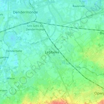
Name: Lebbeke topographic map, elevation, terrain.
Location: Lebbeke, Termonde, Flandre orientale, Flandre, 9280, Belgique (50.96040 4.09077 51.04040 4.17077)
Average elevation: 9 m
Minimum elevation: -1 m
Maximum elevation: 41 m
Other topographic maps
Click on a map to view its topography, its elevation and its terrain.
Oude God
Belgique > Flandre orientale > Termonde > Lebbeke
Oude God, Lebbeke, Termonde, Flandre orientale, Flandre, 9280, Belgique
Average elevation: 7 m