
Lamia topographic map
Click on the map to display elevation.
About this map
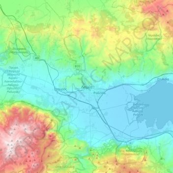
Name: Lamia topographic map, elevation, terrain.
Average elevation: 534 m
Minimum elevation: -4 m
Maximum elevation: 2,141 m
Other topographic maps
Click on a map to view its topography, its elevation and its terrain.
Municipal Unit of Lamia
Greece > Thessaly and Central Greece > Phthiotis Regional Unit
Average elevation: 532 m
Δημοτική Ενότητα Γοργοποτάμου
Greece > Thessaly and Central Greece > Phthiotis Regional Unit
Average elevation: 569 m
Δημοτική Ενότητα Γοργοποτάμου
Greece > Thessaly and Central Greece > Phthiotis Regional Unit
Average elevation: 569 m
Lamia Municipality
Greece > Thessaly and Central Greece > Phthiotis Regional Unit
Average elevation: 611 m