
Make a donation
National Park Djerdap topographic map
Click on the map to display elevation.
Make a donation
National Park Djerdap
The Blederija river springs from two karstic springs at an altitude of 389 m (1,276 ft), under the Topla Bara peak. The springs are 5 m (16 ft) away from each other and one has a water temperature around 8 °C (46 °F), while the other has a constant 17 °C (63 °F). The river forms several cascades in the heavily forested area before creating the Blederija waterfall, 8 m (26 ft) tall. The average discharge varies greatly and during the catastrophic 2014 Southeast Europe floods, the river heavily flooded its lower valley causing damage. There are several caves left of the waterfall and the scenic viewpoint on the location of former medieval town.
Make a donation
About this map
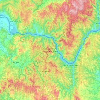
Name: National Park Djerdap topographic map, elevation, terrain.
Average elevation: 420 m
Minimum elevation: 60 m
Maximum elevation: 1,192 m
Make a donation
Other topographic maps
Click on a map to view its topography, its elevation and its terrain.
Stol
Serbia > Central Serbia > Bor Administrative District > Bucje
Stol (Serbian Cyrillic: Стол) is a mountain in eastern Serbia, near the town of Bor. Its highest peak has an elevation of 1,156 meters above sea level. Like nearby Veliki Krš and Mali Krš, Stol has a number of pronounced karst formations. There is a mountain hut with around 35 beds, maintained by the…
Average elevation: 805 m
Bor
Serbia > Central Serbia > Bor Administrative District
Crni Vrh is a mountain 30 km from the city center. Highest peak has an elevation of 1,043 m (3,422 ft) above sea level. It has several ski tracks anda ski lift. The main ski track is 1,100 m long and has height span of 260 m. Just 16 km from the city center there is another mountain Stol. Its highest peak has…
Average elevation: 474 m
Negotin
Serbia > Central Serbia > Bor Administrative District > Negotin Municipality
Average elevation: 86 m
Rajac
Serbia > Central Serbia > Bor Administrative District > Negotin Municipality
Average elevation: 127 m
Make a donation
Prahovo
Serbia > Central Serbia > Bor Administrative District > Negotin Municipality
Average elevation: 48 m