
Dolovo topographic map
Interactive map
Click on the map to display elevation.
About this map
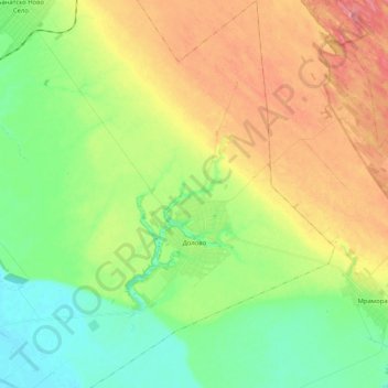
Name: Dolovo topographic map, elevation, terrain.
Average elevation: 118 m
Minimum elevation: 78 m
Maximum elevation: 177 m
Other topographic maps
Click on a map to view its topography, its elevation and its terrain.
Baranda
Serbia > Vojvodina > South Banat Administrative District > Opovo Municipality
Average elevation: 75 m
Alibunar
Serbia > Vojvodina > South Banat Administrative District > Alibunar Municipality
Average elevation: 101 m
Gudurički vrh
Serbia > Vojvodina > South Banat Administrative District > City of Vršac
Average elevation: 330 m
Hajducica
Serbia > Vojvodina > South Banat Administrative District > Plandiste Municipality
Average elevation: 77 m