
Sirach topographic map
Interactive map
Click on the map to display elevation.
About this map
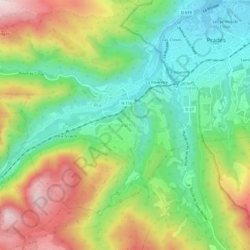
Name: Sirach topographic map, elevation, terrain.
Average elevation: 517 m
Minimum elevation: 326 m
Maximum elevation: 812 m
Other topographic maps
Click on a map to view its topography, its elevation and its terrain.
La Riberette
France > Occitanie > Pyrénées-Orientales > Ria-Sirach > Sirach
La Riberette, Sirach, Ria-Sirach, Prades, Pyrénées-Orientales, Occitanie, France métropolitaine, 66500, France
Average elevation: 479 m