
Thank you for supporting this site ❤️
Make a donation
Make a donation
Feijó topographic map
Click on the map to display elevation.
Thank you for supporting this site ❤️
Make a donation
Make a donation
About this map
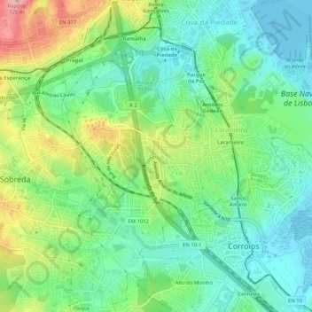
Name: Feijó topographic map, elevation, terrain.
Location: Feijó, Almada, Setúbal, 2810-010, Portugal (38.63298 -9.18656 38.67298 -9.14656)
Average elevation: 41 m
Minimum elevation: -3 m
Maximum elevation: 120 m
Thank you for supporting this site ❤️
Make a donation
Make a donation
Other topographic maps
Click on a map to view its topography, its elevation and its terrain.
Thank you for supporting this site ❤️
Make a donation
Make a donation
Thank you for supporting this site ❤️
Make a donation
Make a donation