
Make a donation
Sugarlands topographic map
Click on the map to display elevation.
Make a donation
Sugarlands
In the 19the century, mountain areas became popular vacation destinations, especially since large urban areas were often wanting for clean air and scenery. Mineral-rich mountain springs were thought to have health-restoring qualities, and the cool air of the higher elevations lured people seeking relief from allergies and hay fever. Colonel W. B. Townsend, the owner of the Little River Lumber Company, began to see the value of creating recreational areas on land that had already been stripped of its wood. In 1909, after the Elkmont area had largely been cleared, the company's train, the Little River Railroad, began offering daily train service from Knoxville to Elkmont in conjunction with Knoxville's Southern Railroad. Tourists also began pouring into Gatlinburg, especially after Andrew Huff opened the Mountain View Hotel in 1916. With the arrival of tourism, Sugarlanders found a wider market for their furs and produce.
Make a donation
About this map
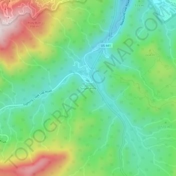
Name: Sugarlands topographic map, elevation, terrain.
Average elevation: 607 m
Minimum elevation: 416 m
Maximum elevation: 981 m
Make a donation
Other topographic maps
Click on a map to view its topography, its elevation and its terrain.
Great Smoky Mountains National Park
United States > Tennessee > Sevier County
Elevations in the park range from about 875 feet (267 m) to 6,643 feet (2,025 m) at the summit of Clingmans Dome. Within the park a total of sixteen mountains reach higher than 5,000 feet (1,520 m).
Average elevation: 765 m
Gatlinburg
United States > Tennessee > Sevier County
Gatlinburg is nestled within the Appalachian Mountains, specifically at the junction of the Ridge-and-Valley and the Blue Ridge provinces, making its topography notably rugged and varied. The town itself sits at an elevation of approximately 1,500 feet above sea level, surrounded by steep ridges and deep…
Average elevation: 577 m
Make a donation
Great Smoky Mountains National Park
United States > Tennessee > Sevier County
Elevations in the park range from about 875 feet (267 m) to 6,643 feet (2,025 m) at the summit of Clingmans Dome. Within the park a total of sixteen mountains reach higher than 5,000 feet (1,520 m).
Average elevation: 765 m
Make a donation
Make a donation
Douglas Dam
United States > Tennessee > Sevier County > Sevierville
The Douglas Project required the construction of ten smaller, earthen saddle dams to fill in gaps along the adjacent ridgeline and permit a higher water elevation than would otherwise be possible. Most of these saddle dams are located in the hills southeast of the main dam. One protects downtown Dandridge,…
Average elevation: 312 m
Make a donation