
Make a donation
Polignano a Mare topographic map
Click on the map to display elevation.
Make a donation
About this map
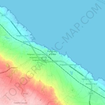
Name: Polignano a Mare topographic map, elevation, terrain.
Location: Polignano a Mare, Bari, Apulia, 70044, Italy (40.95445 17.18249 41.03445 17.26249)
Average elevation: 42 m
Minimum elevation: -4 m
Maximum elevation: 186 m
Make a donation
Other topographic maps
Click on a map to view its topography, its elevation and its terrain.
Make a donation
Make a donation
Santeramo in Colle
By altitude, Santeramo in Colle is the highest municipality in the metropolitan city of Bari.
Average elevation: 418 m
Gioia del Colle
Gioia del Colle is on the top of a hill at 360 m a.s.l. It is located in the southern part of the Murge, in the "Sella di Gioia del Colle". It is between the North-West Murge and the South-West Murge and the Adriatic Sea and the Ionian Sea. The municipal area has an area of 206.48 km2 and it reaches a maximum…
Average elevation: 351 m
Make a donation
Make a donation
Make a donation