
Thank you for supporting this site ❤️
Make a donation
Make a donation
Aarschot topographic map
Click on the map to display elevation.
Thank you for supporting this site ❤️
Make a donation
Make a donation
Aarschot
Een andere verklaring vertrekt van de eerste schriftelijke vermelding van Aarschot in 1107 als Arescod. Deze naam is afgeleid van de Germaanse woorden "arnu" (= arend, dit kan eventueel ook verwijzen naar een persoonsnaam) en "skauta" (= bebost stuk hoger gelegen land, uitspringend in een moerassig terrein). Deze verklaring past ook perfect in de Aarschotse topografie.
Thank you for supporting this site ❤️
Make a donation
Make a donation
About this map
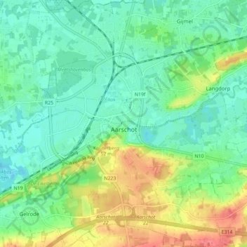
Name: Aarschot topographic map, elevation, terrain.
Location: Aarschot, Leuven, Vlaams-Brabant, Vlaanderen, België (50.95810 4.80040 51.01310 4.87061)
Average elevation: 26 m
Minimum elevation: 4 m
Maximum elevation: 70 m
Thank you for supporting this site ❤️
Make a donation
Make a donation
Other topographic maps
Click on a map to view its topography, its elevation and its terrain.