
Make a donation
Lumbini Province topographic map
Click on the map to display elevation.
Make a donation
Lumbini Province
The elevations of Dang and Deukhuri valleys are 700 meters and 300 meters from sea level respectively. Late Cenozoic sedimentary sequences are well exposed along the southern part of Dang and all sides of Deukhuri valley, and mostly consist of deformed rocks resulting from the persistence of shortening between Indian Plate and Eurasian Plate. The two valleys have been considered a vital location of Paleolithic archeology in South Asia due to the abundant presence of ancient Paleolithic tool sites.
Make a donation
About this map
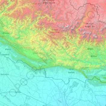
Name: Lumbini Province topographic map, elevation, terrain.
Location: Lumbini Province, Nepal (27.33016 81.05977 28.86928 84.02844)
Average elevation: 1,439 m
Minimum elevation: 73 m
Maximum elevation: 8,121 m
Make a donation
Other topographic maps
Click on a map to view its topography, its elevation and its terrain.
Himalayas
Nepal > Koshi Province > Solukhumbu
The Himalayas present a dramatic and varied topography characterized by towering peaks, deep valleys, and extensive glaciers. This majestic mountain range features some of the highest elevations on Earth, including Mount Everest, which rises to 29,035 feet. The terrain is marked by steep, jagged ridges and…
Average elevation: 7,555 m
Himalayas
Nepal > Koshi Province > Solukhumbu
The Himalayas, or Himalaya (/ˌhɪməˈleɪ.ə, hɪˈmɑːləjə/; Sanskrit: [ɦɪmaːlɐjɐ]; from Sanskrit himá 'snow, frost', and ā-laya 'dwelling, abode'), is a mountain range in Asia, separating the plains of the Indian subcontinent from the Tibetan Plateau. The range has some of the planet's highest…
Average elevation: 7,555 m
Kathmandu
Nepal > Bagmati Province > Kathmandu
Kathmandu is located at an elevation of approximately 4,600 feet (1,400 meters) within the Kathmandu Valley. This valley is characterized by a bowl-like topography, encircled by the lower Himalayan ranges, which rise sharply in the north, culminating in peaks that exceed 24,000 feet (7,300 meters). The…
Average elevation: 1,538 m
Mount Everest
Nepal > Koshi Province > Solukhumbu
Mount Everest (Nepali: सगरमाथा, romanized: Sagarmāthā; Standard Tibetan: ཇོ་མོ་གླང་མ, romanized: Chomolungma; Chinese: 珠穆朗玛峰; pinyin: Zhūmùlǎngmǎ Fēng) is Earth's highest mountain above sea level, located in the Mahalangur Himal sub-range of the Himalayas.…
Average elevation: 7,847 m
Make a donation
Mount Everest
Nepal > Koshi Province > Solukhumbu
Mount Everest is Earth's highest mountain above sea level, located in the Mahalangur Himal sub-range of the Himalayas. The China–Nepal border runs across its summit point. Its elevation (snow height) of 8,848.86 m (29,031 ft 8+1⁄2 in) was most recently established in 2020 by the Chinese and Nepali authorities.
Average elevation: 7,847 m
Mount Everest
Nepal > Koshi Province > Solukhumbu
Mount Everest (Nepali: सगरमाथा, romanized: Sagarmāthā; Standard Tibetan: ཇོ་མོ་གླང་མ, romanized: Chomolungma; Chinese: 珠穆朗玛峰; pinyin: Zhūmùlǎngmǎ Fēng) is Earth's highest mountain above sea level, located in the Mahalangur Himal sub-range of the Himalayas.…
Average elevation: 7,847 m
Mount Everest
Nepal > Eastern Development Region > Khumjung
Mount Everest (Chinese: 珠穆朗玛 Zhūmùlǎngmǎ; Nepali: सगरमाथा Sagarmāthā; Tibetan: Chomolungma ཇོ་མོ་གླང་མ) is Earth's highest mountain above sea level, located in the Mahalangur Himal sub-range of the Himalayas. The China–Nepal border runs across its summit…
Average elevation: 7,841 m
Make a donation
Mount Everest
Nepal > Koshi Province > Solukhumbu
Mount Everest (Nepali: सगरमाथा, romanized: Sagarmāthā; Tibetan: Chomolungma ཇོ་མོ་གླང་མ; Chinese: 珠穆朗玛峰; pinyin: Zhūmùlǎngmǎ Fēng) is Earth's highest mountain above sea level, located in the Mahalangur Himal sub-range of the Himalayas. The China–Nepal…
Average elevation: 7,850 m
Ghorahi
Nepal > Lumbini Province > Dang
Ghorahi is the main town of the Rapti Zone and also the headquarters of the Dang district. It is located at an elevation of 2,300 feet (700 m) in the Mahabharat-Chure hill region.
Average elevation: 865 m
Make a donation
Mount Everest
Nepal > Koshi Province > Solukhumbu
Mount Everest (Nepali: सगरमाथा, romanized: Sagarmāthā; Standard Tibetan: ཇོ་མོ་གླང་མ, romanized: Chomolungma; Chinese: 珠穆朗玛峰; pinyin: Zhūmùlǎngmǎ Fēng) is Earth's highest mountain above sea level, located in the Mahalangur Himal sub-range of the Himalayas.…
Average elevation: 7,847 m
Make a donation
Manaslu
Nepal > Gandaki Province > Gorkha
The Manaslu region offers a variety of trekking options. The popular Manaslu trekking route of 177 kilometres (110 mi) skirts the Manaslu massif over the pass down to Annapurna. The Nepalese Government only permitted trekking on this circuit in 1991. The trekking trail follows an ancient salt-trading route…
Average elevation: 7,069 m
Pokhara
Pokhara is in the northwestern corner of the Pokhara Valley, which is a widening of the Seti Gandaki valley that lies in the region (Pahad) of the Himalayas. In this region the mountains rise very quickly, and within 30 kilometres (19 miles), the elevation rises from 1,000 to 7,500 metres (3,300 to 24,600…
Average elevation: 1,222 m
Gorak Shep
Nepal > Koshi Province > Solukhumbu
Gorak Shep or Gorakshep (Nepali: गोरकशेप) is a small settlement that sits on the edge of a frozen lakebed covered with sand in Nepal with the same name. It is found at an elevation of 5,164 metres (16,942 ft) elevation, near Mount Everest. The village is not inhabited year-round.
Average elevation: 5,255 m
Mount Everest
Nepal > Koshi Province > Solukhumbu
Mount Everest (Nepali: सगरमाथा, romanized: Sagarmāthā; Standard Tibetan: ཇོ་མོ་གླང་མ, romanized: Chomolungma; Chinese: 珠穆朗玛峰; pinyin: Zhūmùlǎngmǎ Fēng) is Earth's highest mountain above sea level, located in the Mahalangur Himal sub-range of the Himalayas.…
Average elevation: 7,847 m
Make a donation
Arun River
Nepal > Koshi Province > Sankhuwasabha > Num
The Tibetan name Bum-chu may refer to a religious ceremony attempting to divine prospects for the coming year from the level of water in a pot or well, chu is the Tibetan word for water. The river originates near Gutso in Nyalam County of Tibet. Around 17 kilometres (11 mi) downstream, the Men-chu joins it.…
Average elevation: 1,153 m
Mount Everest
Nepal > Koshi Province > Solukhumbu
Mount Everest (Nepali: सगरमाथा, romanized: Sagarmāthā; Standard Tibetan: ཇོ་མོ་གླང་མ, romanized: Chomolungma; Chinese: 珠穆朗玛峰; pinyin: Zhūmùlǎngmǎ Fēng) is Earth's highest mountain above sea level, located in the Mahalangur Himal sub-range of the Himalayas.…
Average elevation: 7,847 m
Make a donation
Hadeban Upabhokta Samiti , Lamachaur -19
Nepal > Gandaki Province > Kaski > Pokhara
Average elevation: 1,042 m
Make a donation
Make a donation
Annapurna I
Nepal > Gandaki Province > Myagdi
The mountain is named after Annapurna, the Hindu goddess of food and nourishment, who is said to reside there. The name Annapurna is derived from the Sanskrit-language words purna ("filled") and anna ("food"), and can be translated as "everlasting food". Many streams descending from the slopes of the Annapurna…
Average elevation: 7,126 m
Make a donation
Make a donation
Lalitpur
Nepal > Bagamati Province > Lalitpur
Lalitpur (Nepali: ललितपुर) is a metropolitan city and fourth most populous city of Nepal with 299,843 inhabitants living in 77,159 households per the 2021 census. It is located in the south-central part of Kathmandu Valley, a large valley in the high plateaus in central Nepal, at an altitude of…
Average elevation: 1,608 m
Make a donation
Make a donation
Make a donation
Machapuchare
Nepal > Gandaki Province > Kaski
Due to its southern position in the range and the particularly low terrain that lies south of the Annapurna Himalayas, which contains three of the 10 highest peaks in the world, Machapuchare commands tremendous vertical relief in a short horizontal distance. This, combined with its steep, pointed profile,…
Average elevation: 5,746 m
Hillary Step
Nepal > Koshi Province > Solukhumbu
The step was named after Sir Edmund Hillary, who partnered with Sherpa Tenzing Norgay, on 29 May 1953 climbing the crack between the snow and the rock, earning the feature its name. Upon completion of the summit, the pair reported the snowpack on Hillary is harder than that of lower elevation.
Average elevation: 7,824 m
Make a donation
Ghorahi
Nepal > Lumbini Province > Dang
Ghorahi is the main town of the Rapti Zone and also the headquarters of the Dang district. It is located at an elevation of 2,300 feet (700 m) in the Mahabharat-Chure hill region.
Average elevation: 865 m
Make a donation
Make a donation
Himalayas
Nepal > Koshi Province > Solukhumbu
The Himalayas, or Himalaya (/ˌhɪməˈleɪ.ə, hɪˈmɑːləjə/ HIM-ə-LAY-ə, hih-MAH-lə-yə) is a mountain range in Asia, separating the plains of the Indian subcontinent from the Tibetan Plateau. The range has some of the Earth's highest peaks, including the highest, Mount Everest. More than 100 peaks…
Average elevation: 7,555 m
Make a donation
Lalitpur
Nepal > Bagamati Province > Lalitpur
Lalitpur Metropolitan City (Sanskrit: पाटन Pāṭana, Nepal bhasa : 𑐫𑐮 Yala) is a metropolitan city and fourth most populous city of Nepal with 299,843 inhabitants living in 49,044 households per the 2021 census. It is located in the south-central part of Kathmandu Valley, a large valley in…
Average elevation: 1,608 m
Make a donation
Make a donation
Make a donation
Lalitpur
Nepal > Bagamati Province > Lalitpur
Lalitpur (Nepali: ललितपुर) is a metropolitan city and fourth most populous city of Nepal with 299,843 inhabitants living in 77,159 households per the 2021 census. It is located in the south-central part of Kathmandu Valley, a large valley in the high plateaus in central Nepal, at an altitude of…
Average elevation: 1,608 m
Make a donation
Make a donation
Bhimad
Nepal > Gandaki Province > Tanahun
Rangrung is famous for its altitude, accessing panoramic views of the broad Himalayan range. Hill Tower with telescope facilities will be constructed in the near future. This is popular for the resorts and overnight stayers. It has enormous potential for paragliding, this area is also famous for biodiversity.…
Average elevation: 544 m
Make a donation
Lhotse
Nepal > Koshi Province > Solukhumbu
Lhotse (Nepali: ल्होत्से, romanized: L'hōtsē [lotse]; Standard Tibetan: ལྷོ་རྩེ, romanized: lho tse, lit. 'South Peak' [l̥otse]; Chinese: 洛子峰) is the fourth-highest mountain on Earth, after Mount Everest, K2, and Kangchenjunga. At an elevation of 8,516 metres (27,940…
Average elevation: 7,391 m
Make a donation
Manaslu
Nepal > Gandaki Province > Gorkha
The Manaslu region offers a variety of trekking options. The popular Manaslu trekking route of 177 kilometres (110 mi) skirts the Manaslu massif over the pass down to Annapurna. The Nepalese Government only permitted trekking on this circuit in 1991. The trekking trail follows an ancient salt-trading route…
Average elevation: 7,069 m
Make a donation