
La Chevalière topographic map
Interactive map
Click on the map to display elevation.
About this map
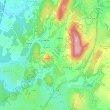
Name: La Chevalière topographic map, elevation, terrain.
Average elevation: 290 m
Minimum elevation: 219 m
Maximum elevation: 427 m
Other topographic maps
Click on a map to view its topography, its elevation and its terrain.
Au Roi
France > Bourgogne-Franche-Comté > Jura > L'Étoile > La Chevalière
Au Roi, La Chevalière, L'Étoile, Lons-le-Saunier, Jura, Bourgogne-Franche-Comté, France métropolitaine, 39570, France
Average elevation: 299 m