
Thank you for supporting this site ❤️
Make a donation
Make a donation
Seyboldsdorf topographic map
Click on the map to display elevation.
Thank you for supporting this site ❤️
Make a donation
Make a donation
Seyboldsdorf
Das Pfarrdorf Seyboldsdorf liegt gut drei Kilometer nördlich von Vilsbiburg auf einem Höhenrücken im Isar-Inn-Hügelland zwischen Großer und Kleiner Vils.
Thank you for supporting this site ❤️
Make a donation
Make a donation
About this map
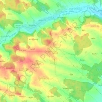
Name: Seyboldsdorf topographic map, elevation, terrain.
Average elevation: 470 m
Minimum elevation: 435 m
Maximum elevation: 504 m
Thank you for supporting this site ❤️
Make a donation
Make a donation
Other topographic maps
Click on a map to view its topography, its elevation and its terrain.
84137
Deutschland > Bayern > Landkreis Landshut > Vilsbiburg > Gaindorf > Berg
Average elevation: 455 m