
Make a donation
East Godavari topographic map
Click on the map to display elevation.
Make a donation
About this map
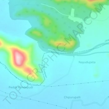
Name: East Godavari topographic map, elevation, terrain.
Location: East Godavari, Andhra Pradesh, India (17.21350 81.70260 17.25350 81.74260)
Average elevation: 64 m
Minimum elevation: 19 m
Maximum elevation: 310 m
Make a donation
Other topographic maps
Click on a map to view its topography, its elevation and its terrain.
Make a donation
Anantapuram
Penna, Chithravathi, Pedda Hagari, Chinna Hagari, Thadakaleru and Pandameru are the main rivers. The average elevation is about 1300 feet above the mean sea level. The annual normal rainfall of the district is 508.2 mm. Thus it secures least rainfall when compared to other parts of Andhra Pradesh.
Average elevation: 455 m
Make a donation
Make a donation
Make a donation
Make a donation
Make a donation
Make a donation
Make a donation
Make a donation
Make a donation
Make a donation
Make a donation
Make a donation
Nandyal
Nandyal district lies between the northern latitudes of 15° 27’ 49’’ and eastern longitudes of 78° 28’ 43’’. The altitude of the district varies from 100 ft above the mean sea level. This district is bounded on the north by Krishna rivers as well as Mahabubnagar district of Telangana State, on…
Average elevation: 337 m
Make a donation
Make a donation
Make a donation
Make a donation
Make a donation
Make a donation
Make a donation
Make a donation
Make a donation
Make a donation
Make a donation
Make a donation