
Linn Grove topographic map
Interactive map
Click on the map to display elevation.
About this map
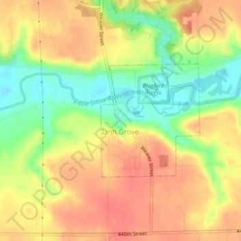
Name: Linn Grove topographic map, elevation, terrain.
Location: Linn Grove, Buena Vista County, Iowa, United States (42.88614 -95.24968 42.89887 -95.23453)
Average elevation: 407 m
Minimum elevation: 374 m
Maximum elevation: 429 m
Other topographic maps
Click on a map to view its topography, its elevation and its terrain.
Newell
United States > Iowa > Buena Vista County
Newell, Buena Vista County, Iowa, United States
Average elevation: 384 m
Lakeside
United States > Iowa > Buena Vista County
Lakeside, Buena Vista County, Iowa, United States
Average elevation: 427 m