
Thank you for supporting this site ❤️
Make a donation
Make a donation
Sullivan topographic map
Click on the map to display elevation.
Thank you for supporting this site ❤️
Make a donation
Make a donation
About this map
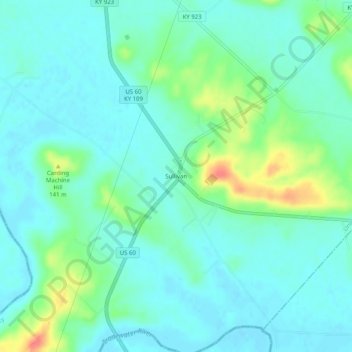
Name: Sullivan topographic map, elevation, terrain.
Location: Sullivan, Union County, Kentucky, 42460, United States (37.47755 -87.96530 37.51755 -87.92530)
Average elevation: 118 m
Minimum elevation: 104 m
Maximum elevation: 163 m
Thank you for supporting this site ❤️
Make a donation
Make a donation
Other topographic maps
Click on a map to view its topography, its elevation and its terrain.
Breckinridge Center
United States > Kentucky > Union County > Breckinridge Center
Average elevation: 128 m