Geolocate

Alexandria topographic map

Interactive map

Click on the map to display elevation.

About this map

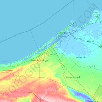
Name: Alexandria topographic map, elevation, terrain.

Location: Alexandria, Egypt (30.35968 29.47161 31.59032 30.09312)

Average elevation: 25 m

Minimum elevation: -25 m

Maximum elevation: 186 m

Other topographic maps

Click on a map to view its topography, its elevation and its terrain.

Warraq al Hadar

Egypt > Giza

Average elevation: 21 m

Giza

Egypt > Giza

Average elevation: 72 m

Mudiriyat al Gharbiyah

Egypt > Seberbay

Average elevation: 46 m

Tizmant East Village

Egypt > Bani Sweif

Average elevation: 30 m

El Alamein

Egypt > Matrouh > El Alamein

Average elevation: 19 m

Al Shaykh Fadl

Egypt > Minya Governate > Al Shaykh Fadl

Average elevation: 35 m