
Thank you for supporting this site ❤️
Make a donation
Make a donation
Straubing topographic map
Click on the map to display elevation.
Thank you for supporting this site ❤️
Make a donation
Make a donation
Straubing
In Straubing (Wittelsbacherhöhe 3) liegt die Verwaltung von BayernWLAN.
Thank you for supporting this site ❤️
Make a donation
Make a donation
About this map
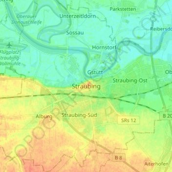
Name: Straubing topographic map, elevation, terrain.
Location: Straubing, Bayern, 94315, Deutschland (48.84198 12.52972 48.92198 12.60972)
Average elevation: 327 m
Minimum elevation: 313 m
Maximum elevation: 347 m
Thank you for supporting this site ❤️
Make a donation
Make a donation
Other topographic maps
Click on a map to view its topography, its elevation and its terrain.