
Thank you for supporting this site ❤️
Make a donation
Make a donation
Lembach topographic map
Click on the map to display elevation.
Thank you for supporting this site ❤️
Make a donation
Make a donation
Lembach
The commune, which covers an extensive land area, much of it uninhabitable owing to the topography, also includes the small village of Mattstall and the hamlet of Pfaffenbronn.
Thank you for supporting this site ❤️
Make a donation
Make a donation
About this map
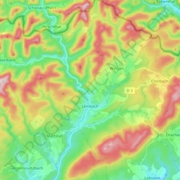
Name: Lembach topographic map, elevation, terrain.
Average elevation: 319 m
Minimum elevation: 169 m
Maximum elevation: 550 m
Thank you for supporting this site ❤️
Make a donation
Make a donation
Other topographic maps
Click on a map to view its topography, its elevation and its terrain.
Thank you for supporting this site ❤️
Make a donation
Make a donation
Thank you for supporting this site ❤️
Make a donation
Make a donation
Thank you for supporting this site ❤️
Make a donation
Make a donation
Quartier des Aviateurs
France > Grand Est > Bas-Rhin > Sélestat > Quartier des Aviateurs
Average elevation: 175 m
Thank you for supporting this site ❤️
Make a donation
Make a donation