
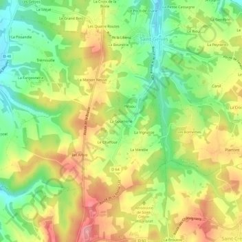
La Gournerie topographic map
Interactive map
Click on the map to display elevation.
About this map
Name: La Gournerie topographic map, elevation, terrain.
Average elevation: 242 m
Minimum elevation: 188 m
Maximum elevation: 298 m
Other topographic maps
Click on a map to view its topography, its elevation and its terrain.
Pelvezy
France > Nouvelle-Aquitaine > Dordogne > Saint-Geniès
Pelvezy, Impasse des Sources, Les Farges, Saint-Geniès, Sarlat-la-Canéda, Dordogne, Nouvelle-Aquitaine, France métropolitaine, 24590, France
Average elevation: 222 m
Les Tuilières
France > Nouvelle-Aquitaine > Dordogne > Saint-Geniès > Les Tuilières
Les Tuilières, Saint-Geniès, Sarlat-la-Canéda, Dordogne, Nouvelle-Aquitaine, France métropolitaine, 24590, France
Average elevation: 250 m
Le Pech de Diane
France > Nouvelle-Aquitaine > Dordogne > Saint-Geniès
Le Pech de Diane, Saint-Geniès, Sarlat-la-Canéda, Dordogne, Nouvelle-Aquitaine, France métropolitaine, 24590, France
Average elevation: 231 m