
Little Guilin topographic map
Interactive map
Click on the map to display elevation.
About this map
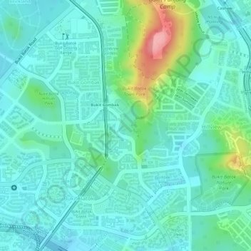
Name: Little Guilin topographic map, elevation, terrain.
Average elevation: 38 m
Minimum elevation: 8 m
Maximum elevation: 135 m
Other topographic maps
Click on a map to view its topography, its elevation and its terrain.
Jurong Hill Park
Jurong Hill Park, Boon Lay, Southwest, Singapore
Average elevation: 11 m
Bishan-Ang Mo Kio Park
Bishan-Ang Mo Kio Park, Ang Mo Kio Neighbourhood Marker Sign, Bishan, Central, Singapore
Average elevation: 21 m
Bukit Batok Nature Park
Bukit Batok Nature Park, Bukit Batok East Avenue 6, Bukit Batok, Southwest, 659761, Singapore
Average elevation: 45 m
Bishan Active Park
Bishan Active Park, Bishan, Singapore, Central, Singapore
Average elevation: 19 m
Raffles Lighthouse
Raffles Lighthouse, Southern Islands, Southwest, Singapore
Average elevation: 1 m
Lower Peirce Reservoir
Lower Peirce Reservoir, Boardwalk, Ang Mo Kio Neighbourhood Marker Sign, Thomson, Singapore, Central, 574416, Singapore
Average elevation: 33 m
Palau Tekong Camp
Palau Tekong Camp, Kampong Ladang, Southeast, Singapore
Average elevation: 5 m
Bedok Reservoir
Bedok Reservoir, Obstacle Course at Forest Adventure, Tampines, Northeast, 479233, Singapore
Average elevation: 23 m
Bukit Timah Nature Reserve
Bukit Timah Nature Reserve, Lorong Pisang Udang, Bukit Batok, Southwest, 598681, Singapore
Average elevation: 52 m