
Ramotswa topographic map
Interactive map
Click on the map to display elevation.
About this map
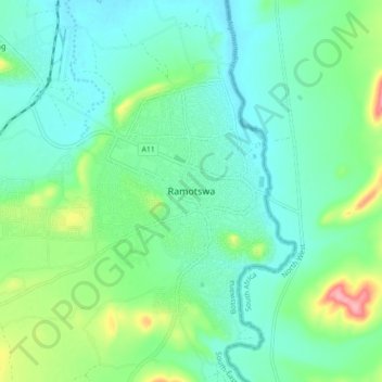
Name: Ramotswa topographic map, elevation, terrain.
Location: Ramotswa, South-East District, Botswana (-24.91104 25.82516 -24.83104 25.90516)
Average elevation: 1,043 m
Minimum elevation: 1,016 m
Maximum elevation: 1,126 m
Other topographic maps
Click on a map to view its topography, its elevation and its terrain.
Gaborone
Botswana > South-East District
Gaborone, South-East District, Botswana
Average elevation: 1,032 m
Kgale Hill
Botswana > South-East District > Gaborone
Kgale Hill, Gaborone, South-East District, 26081 GAMECITY, Botswana
Average elevation: 1,064 m
Tlokweng
Botswana > South-East District > Tlokweng
Tlokweng, South-East District, Botswana
Average elevation: 992 m
Lobatse
Botswana > South-East District > Lobatse
Lobatse, South-East District, Botswana
Average elevation: 1,248 m
Gaborone Dam
Botswana > South-East District > Gaborone
Gaborone Dam, Gaborone, South-East District, Botswana
Average elevation: 992 m
Mogobane
Botswana > South-East District > Mogobane
Mogobane, South-East District, Botswana
Average elevation: 1,091 m