
Blanchardstown topographic map
Interactive map
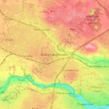
Click on the map to display elevation.
About this map
Name: Blanchardstown topographic map, elevation, terrain.
Average elevation: 61 m
Minimum elevation: 4 m
Maximum elevation: 98 m
Blanchardstown was a predominantly rural area, with a small village, in western County Dublin, alongside the neighbouring district of Castleknock. Both areas shared a common history until well into the 19th century, when their development diverged. In A Topographical Dictionary of Ireland, published in 1837, Blanchardstown is described as "a village [..] on the road to Navan, containing 57 houses and 342 inhabitants".
Other topographic maps
Click on a map to view its topography, its elevation and its terrain.
Lucan
Lucan, South Dublin, County Dublin, Leinster, K78 Y0F1, Ireland
Average elevation: 59 m
Westmanstown
Westmanstown, Lucan North DED 1986, Fingal, County Dublin, Leinster, Ireland
Average elevation: 54 m
Dún Laoghaire
Ireland > County Dublin > Dún Laoghaire
Dún Laoghaire, Dún Laoghaire-Rathdown, County Dublin, Leinster, A96 A258, Ireland
Average elevation: 21 m