
High Rolls topographic map
Interactive map
Click on the map to display elevation.
About this map
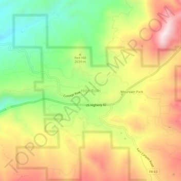
Name: High Rolls topographic map, elevation, terrain.
Location: High Rolls, Otero County, New Mexico, 88325, United States (32.93092 -105.85554 32.97092 -105.81554)
Average elevation: 2,036 m
Minimum elevation: 1,756 m
Maximum elevation: 2,322 m
The first official use of the High Rolls name was in 1901, when the post office was moved from Fresnal (Wooten) to High Rolls. The name, which was sometimes spelled as one word, Highrolls, supposedly came from the shape and elevation of the area as compared to the sharper peaks higher up.
Other topographic maps
Click on a map to view its topography, its elevation and its terrain.
Cloudcroft
United States > New Mexico > Otero County
Cloudcroft, Otero County, New Mexico, United States
Average elevation: 2,643 m
La Luz
United States > New Mexico > Otero County
La Luz, Otero County, New Mexico, 88337, United States
Average elevation: 1,452 m
Orogrande
United States > New Mexico > Otero County
Orogrande, Otero County, New Mexico, 88342, United States
Average elevation: 1,285 m
Weed
United States > New Mexico > Otero County
Weed, Otero County, New Mexico, 88354, United States
Average elevation: 2,212 m
Timberon
United States > New Mexico > Otero County
Timberon, Otero County, New Mexico, 88350, United States
Average elevation: 2,181 m
Apache
United States > New Mexico > Otero County
Apache, Otero County, New Mexico, United States
Average elevation: 1,957 m
Cloudcroft
United States > New Mexico > Otero County > Cloudcroft
Cloudcroft, Otero County, New Mexico, 88317, United States
Average elevation: 2,636 m
White Sands National Park
United States > New Mexico > Otero County
White Sands National Park, Otero County, New Mexico, United States
Average elevation: 1,214 m
Alamogordo
United States > New Mexico > Otero County
Alamogordo, Otero County, New Mexico, 88310, United States
Average elevation: 1,644 m
Alamogordo
United States > New Mexico > Otero County
Alamogordo, Otero County, New Mexico, United States
Average elevation: 1,515 m
La Luz
United States > New Mexico > Otero County
La Luz, Otero County, New Mexico, 88337, United States
Average elevation: 1,493 m
Mayhill
United States > New Mexico > Otero County
Mayhill, Otero County, New Mexico, United States
Average elevation: 2,104 m
Sacramento
United States > New Mexico > Otero County
Sacramento, Otero County, New Mexico, 88347, United States
Average elevation: 2,320 m