
Collier County topographic map
Interactive map
Click on the map to display elevation.
About this map
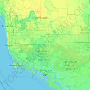
Name: Collier County topographic map, elevation, terrain.
Location: Collier County, Florida, USA (25.76945 -81.90550 26.51707 -80.87299)
Average elevation: 5 m
Minimum elevation: -2 m
Maximum elevation: 21 m
Other topographic maps
Click on a map to view its topography, its elevation and its terrain.
Miami River
Miami River, Miami, Miami-Dade County, Florida, 33128, USA
Average elevation: 9 m
Presbyterian Villas Of Lehigh
USA > Florida > Presbyterian Villas Of Lehigh
Presbyterian Villas Of Lehigh, Lee County, Florida, 33936, USA
Average elevation: 10 m
Dawson Island
USA > Florida > Jacksonville
Dawson Island, Jacksonville, Duval County, Florida, USA
Average elevation: 2 m
St. Augustine
USA > Florida > St. Augustine
St. Augustine, St. Johns County, Florida, 32084, USA
Average elevation: 5 m