
Kings Park topographic map
Interactive map
Click on the map to display elevation.
About this map
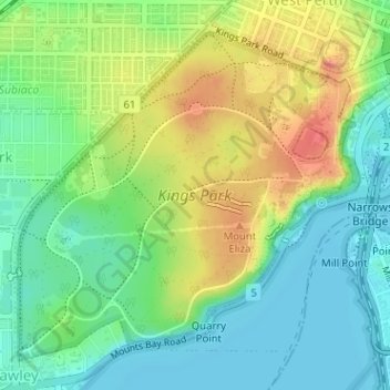
Name: Kings Park topographic map, elevation, terrain.
Average elevation: 31 m
Minimum elevation: 0 m
Maximum elevation: 81 m
Other topographic maps
Click on a map to view its topography, its elevation and its terrain.
Langley Park
Australia > Western Australia > City of Perth > Perth
Langley Park, East Perth, Perth, City of Perth, Western Australia, Australia
Average elevation: 9 m
Crawley
Australia > Western Australia > City of Perth > Perth
Crawley, Perth, City of Perth, Western Australia, 6009, Australia
Average elevation: 13 m
Northbridge
Australia > Western Australia > City of Perth > Perth
Northbridge, Perth, City of Perth, Western Australia, 6003, Australia
Average elevation: 24 m
Russell Square
Australia > Western Australia > City of Perth > Perth
Russell Square, Northbridge, Perth, City of Perth, Western Australia, Australia
Average elevation: 25 m
Acacia Garden
Australia > Western Australia > City of Perth > Perth
Acacia Garden, Kings Park, Perth, City of Perth, Western Australia, 6005, Australia
Average elevation: 27 m