
Lake Champlain topographic map
Interactive map
Click on the map to display elevation.
About this map
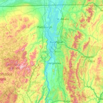
Name: Lake Champlain topographic map, elevation, terrain.
Location: Lake Champlain, Essex County, New York, USA (43.70218 -73.46064 45.12885 -73.06337)
Average elevation: 341 m
Minimum elevation: 26 m
Maximum elevation: 1,543 m
Other topographic maps
Click on a map to view its topography, its elevation and its terrain.
Staten Island
Staten Island, Richmond County, New York, USA
Average elevation: 11 m
Chestnut Creek
Chestnut Creek, Town of Neversink, Sullivan County, New York, 12765, USA
Average elevation: 470 m
Gooseberry Hill
Gooseberry Hill, Essex County, New York, 12872, USA
Average elevation: 304 m
City of Saratoga Springs
USA > New York > City of Saratoga Springs
City of Saratoga Springs, Saratoga County, New York, USA
Average elevation: 95 m
Mount Warren
Mount Warren, Town of Bovina, Delaware County, New York, USA
Average elevation: 677 m
West Bay Shore
USA > New York > West Bay Shore
West Bay Shore, Suffolk County, New York, USA
Average elevation: 7 m
Roosevelt Island
USA > New York > New York City
Roosevelt Island, Manhattan Community Board 8, New York County, New York City, New York, 10044, USA
Average elevation: 13 m
Adirondack
USA > New York > Adirondack
Adirondack, Town of Horicon, Warren County, New York, 12808, USA
Average elevation: 294 m
Big Bear Mountain
Big Bear Mountain, Town of Johnsburg, Warren County, New York, USA
Average elevation: 616 m
Niagara Falls
USA > New York > Niagara Falls
Niagara Falls, Niagara County, New York, USA
Average elevation: 180 m
Avalanche Lake
Avalanche Lake, Avalanche Pass Trail, Essex County, New York, USA
Average elevation: 1,066 m
Livingston Island
Livingston Island, Town of Philipstown, Putnam County, New York, 10922, USA
Average elevation: 156 m
Flat Top Mountain
Flat Top Mountain, Franklin County, New York, USA
Average elevation: 568 m
Sawtooth Mountains
Sawtooth Mountains, Franklin County, New York, USA
Average elevation: 927 m
Devil's Gorge
Devil's Gorge, Town of Rockland, Sullivan County, New York, USA
Average elevation: 730 m