
Talas topographic map
Interactive map
Click on the map to display elevation.
About this map
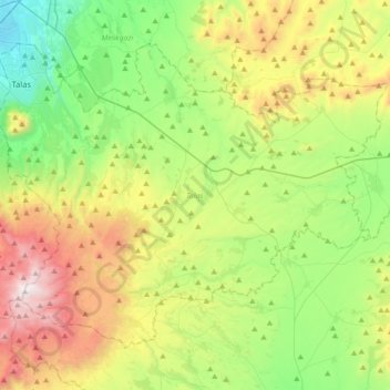
Name: Talas topographic map, elevation, terrain.
Location: Talas, Kayseri, Central Anatolia Region, Turkey (38.50279 35.53101 38.72038 35.88634)
Average elevation: 1,611 m
Minimum elevation: 1,065 m
Maximum elevation: 2,622 m
Other topographic maps
Click on a map to view its topography, its elevation and its terrain.
Beyşehir
Turkey > Central Anatolia Region
Beyşehir, Konya, Central Anatolia Region, Turkey
Average elevation: 1,330 m
Güneşevler Mahallesi
Turkey > Central Anatolia Region > Güneşevler Mahallesi
Güneşevler Mahallesi, Altındağ, Ankara, Central Anatolia Region, Turkey
Average elevation: 900 m
Benzer
Turkey > Central Anatolia Region > Benzer
Benzer, Kaman, Kırşehir, Central Anatolia Region, Turkey
Average elevation: 1,023 m
Basri
Turkey > Central Anatolia Region > Basri
Basri, Polatlı, Ankara, Central Anatolia Region, Turkey
Average elevation: 968 m