
Moncayo topographic map
Interactive map
Click on the map to display elevation.
About this map
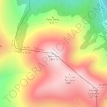
Name: Moncayo topographic map, elevation, terrain.
Location: Moncayo, Ágreda, Soria, Castilla y León, España (41.78711 -1.83976 41.78721 -1.83966)
Average elevation: 1,954 m
Minimum elevation: 1,466 m
Maximum elevation: 2,313 m
Other topographic maps
Click on a map to view its topography, its elevation and its terrain.
Valverde de Ágreda
España > Castilla y León > Ágreda
Valverde de Ágreda, Ágreda, Soria, Castilla y León, España
Average elevation: 801 m