
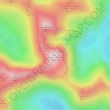
Carrauntoohil topographic map
Interactive map
Click on the map to display elevation.
About this map
Name: Carrauntoohil topographic map, elevation, terrain.
Average elevation: 643 m
Minimum elevation: 298 m
Maximum elevation: 1,017 m
Carrauntoohil is the highest mountain in Ireland on all classification scales. It is the 133rd-highest mountain, and 4th most prominent mountain, in Britain and Ireland, on the Simms classification. Carrauntoohil is regarded by the Scottish Mountaineering Club (SMC) as one of 34 Furths, which are defined as mountains above 3,000 feet (910 m) in elevation and meeting the SMC criteria for a Munro (i.e. "sufficient separation"), and which are outside (or furth), of Scotland; this is why Carrauntoohil is also referred to as one of the thirteen Irish Munros.
Other topographic maps
Click on a map to view its topography, its elevation and its terrain.
Blanchardstown
Blanchardstown, Fingal, County Dublin, Leinster, D15 KPW7, Ireland
Average elevation: 61 m
Lucan
Lucan, South Dublin, County Dublin, Leinster, K78 Y0F1, Ireland
Average elevation: 59 m
Westmanstown
Westmanstown, Lucan North DED 1986, Fingal, County Dublin, Leinster, Ireland
Average elevation: 54 m
Garadice
Garadice, Gallow ED, The Municipal District of Trim, County Meath, Leinster, Ireland
Average elevation: 111 m
Stranorlar
Stranorlar, Lifford-Stranorlar Municipal District, County Donegal, F93 HY64, Ireland
Average elevation: 92 m
Ballina
Ballina, Ballina Municipal District, County Mayo, Connacht, Ireland
Average elevation: 19 m
Thurles
Thurles, The Municipal District of Thurles, County Tipperary, Munster, Ireland
Average elevation: 101 m
Dungarvan
Dungarvan, The Municipal District of Dungarvan — Lismore, County Waterford, Munster, X35 V670, Ireland
Average elevation: 30 m
Waterford
Waterford, County Waterford, Munster, Ireland
Average elevation: 33 m
Ennis Municipal District
Ennis Municipal District, County Clare, Munster, Ireland
Average elevation: 39 m
Galway City
Galway City, County Galway, Connacht, Ireland
Average elevation: 16 m
Dún Laoghaire
Ireland > County Dublin > Dún Laoghaire
Dún Laoghaire, Dún Laoghaire-Rathdown, County Dublin, Leinster, A96 A258, Ireland
Average elevation: 21 m
Killarney Municipal District
Killarney Municipal District, County Kerry, Munster, Ireland
Average elevation: 191 m
Lugnaquilla
Lugnaquilla, The Municipal District of Baltinglass, County Wicklow, Leinster, Ireland
Average elevation: 697 m
Tibradden ED
Tibradden ED, Dublin 16, Dún Laoghaire-Rathdown, County Dublin, Leinster, Ireland
Average elevation: 236 m
Ferns Upper
Ferns Upper, Ferns, County Wexford, Leinster, Ireland
Average elevation: 59 m
Pollaphuca
Pollaphuca, Kiltullagh Electoral Division, Roscommon Municipal District, County Roscommon, Connacht, Ireland
Average elevation: 63 m
Wicklow Mountains National Park
Wicklow Mountains National Park, Mullaghcleevaun to Moanbane and Silsean, Glenbride, Lackan, The Municipal District of Baltinglass, County Wicklow, Leinster, Ireland
Average elevation: 324 m
Cherry Orchard
Cherry Orchard, Merchants Quay E ED, Dublin 8, Dublin, County Dublin, Leinster, Ireland
Average elevation: 25 m
Beenkeragh
Beenkeragh, Kenmare Municipal District, County Kerry, Munster, Ireland
Average elevation: 656 m