
Pittsburg topographic map
Interactive map
Click on the map to display elevation.
About this map
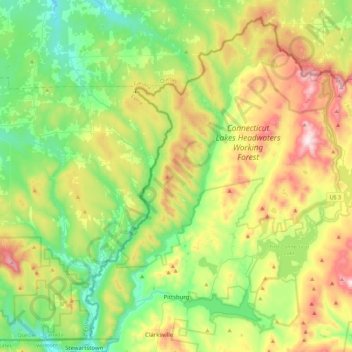
Name: Pittsburg topographic map, elevation, terrain.
Location: Pittsburg, Coös County, New Hampshire, United States (45.01345 -71.50661 45.30578 -71.05950)
Average elevation: 522 m
Minimum elevation: 295 m
Maximum elevation: 953 m
The highest point in Pittsburg is the summit of Stub Hill, at 3,627 feet (1,106 m). Mount Magalloway, elevation 3,383 feet (1,031 m), is a prominent summit reachable by hiking trail.
Other topographic maps
Click on a map to view its topography, its elevation and its terrain.
Kidderville
United States > New Hampshire > Coos County > Colebrook
Kidderville, Colebrook, Coös County, New Hampshire, United States
Average elevation: 472 m
Dixville
United States > New Hampshire > Coos County
Dixville, Coös County, New Hampshire, United States
Average elevation: 635 m
Mount Washington
United States > New Hampshire > Coos County
Mount Washington, Coös County, New Hampshire, United States
Average elevation: 1,568 m
Northumberland
United States > New Hampshire > Coos County
Northumberland, Coös County, New Hampshire, United States
Average elevation: 383 m
Stark
United States > New Hampshire > Coos County
Stark, Coös County, New Hampshire, United States
Average elevation: 526 m
Shelburne
United States > New Hampshire > Coos County
Shelburne, Coös County, New Hampshire, United States
Average elevation: 467 m
Groveton
United States > New Hampshire > Coos County
Groveton, Northumberland, Coös County, New Hampshire, United States
Average elevation: 304 m
Columbia
United States > New Hampshire > Coos County
Columbia, Coös County, New Hampshire, United States
Average elevation: 553 m
Dummer
United States > New Hampshire > Coos County
Dummer, Coös County, New Hampshire, United States
Average elevation: 419 m
Twin Mountain
United States > New Hampshire > Coos County > Carroll
Twin Mountain, Carroll, Coös County, New Hampshire, 03595, United States
Average elevation: 490 m
Pinkham Notch
United States > New Hampshire > Coos County
Pinkham Notch, Pinkham's Grant, Coös County, New Hampshire, United States
Average elevation: 767 m
Milan
United States > New Hampshire > Coos County
Milan, Coös County, New Hampshire, 03588, United States
Average elevation: 448 m
Stratford
United States > New Hampshire > Coos County
Stratford, Coös County, New Hampshire, 03590, United States
Average elevation: 497 m
Castellated Ridge
United States > New Hampshire > Coos County
Castellated Ridge, Low and Burbank's Grant, Coös County, New Hampshire, United States
Average elevation: 1,080 m
Lost Nation
United States > New Hampshire > Coos County > Northumberland
Lost Nation, Northumberland, Coös County, New Hampshire, United States
Average elevation: 363 m
North Stratford
United States > New Hampshire > Coos County
North Stratford, Stratford, Coös County, New Hampshire, 03590, United States
Average elevation: 340 m
Colebrook
United States > New Hampshire > Coos County
Colebrook, Coös County, New Hampshire, 03576, United States
Average elevation: 476 m
Whitefield
United States > New Hampshire > Coos County
Whitefield, Coös County, New Hampshire, United States
Average elevation: 365 m
Gorham
United States > New Hampshire > Coos County
Gorham, Coös County, New Hampshire, 03581, United States
Average elevation: 477 m
Wildcat Mountain
United States > New Hampshire > Coos County
Wildcat Mountain, Coös County, New Hampshire, United States
Average elevation: 1,055 m
Upper Kidderville
United States > New Hampshire > Coos County > Colebrook
Upper Kidderville, Colebrook, Coos County, New Hampshire, United States
Average elevation: 478 m
Castle Mountain
United States > New Hampshire > Coos County
Castle Mountain, Coos County, New Hampshire, United States
Average elevation: 937 m
Carroll
United States > New Hampshire > Coos County
Carroll, Coös County, New Hampshire, United States
Average elevation: 562 m
Lancaster
United States > New Hampshire > Coos County
Lancaster, Coös County, New Hampshire, 03584, United States
Average elevation: 371 m
Bretton Woods
United States > New Hampshire > Coos County > Carroll
Bretton Woods, Carroll, Coös County, New Hampshire, 03575, United States
Average elevation: 577 m
Clarksville
United States > New Hampshire > Coos County
Clarksville, Coös County, New Hampshire, United States
Average elevation: 570 m
Mount Crescent
United States > New Hampshire > Coos County
Mount Crescent, Coos County, New Hampshire, 03593, United States
Average elevation: 748 m
Triple Falls
United States > New Hampshire > Coos County > Gorham
Triple Falls, Gorham, Coos County, New Hampshire, 03593, United States
Average elevation: 558 m
Randolph
United States > New Hampshire > Coos County
Randolph, Coös County, New Hampshire, 03593, United States
Average elevation: 594 m
LIttle Diamond Pond
United States > New Hampshire > Coos County > Stewartstown
LIttle Diamond Pond, Stewartstown, Coos County, New Hampshire, United States
Average elevation: 693 m
Jefferson Highland
United States > New Hampshire > Coos County > Jefferson > Jefferson Highland
Jefferson Highland, Jefferson, Coos County, New Hampshire, 03583, United States
Average elevation: 451 m
Jefferson
United States > New Hampshire > Coos County
Jefferson, Coös County, New Hampshire, 03583, United States
Average elevation: 493 m
Dixville Notch
United States > New Hampshire > Coos County
Dixville Notch, Coos County, New Hampshire, United States
Average elevation: 655 m
Stewartstown
United States > New Hampshire > Coos County
Stewartstown, Coös County, New Hampshire, 03597, United States
Average elevation: 485 m
Dalton
United States > New Hampshire > Coos County
Dalton, Coös County, New Hampshire, United States
Average elevation: 375 m
Errol
United States > New Hampshire > Coos County
Errol, Coös County, New Hampshire, United States
Average elevation: 453 m
Mount Eisenhower
United States > New Hampshire > Coos County
Mount Eisenhower, Coos County, New Hampshire, 03589, United States
Average elevation: 1,142 m